
The Arctic, a region already experiencing the front lines of global climatic transformation, has provided a stark reminder of its instability. In August 2026, the Petermann Glacier—a massive, marine-terminating ice stream on Greenland’s northwest coast—shed a colossal iceberg, an event that has rippled through the scientific community and reignited concerns regarding the long-term health of the Greenland Ice Sheet.
Roughly the size of St. Thomas in the U.S. Virgin Islands, the iceberg, classified by researchers as an "ice island," represents the most significant calving event in the Arctic since 2020. As climate change accelerates the thinning of polar ice shelves, the behavior of glaciers like Petermann has become a critical indicator for sea-level projections and oceanographic stability.
The Chronology of a Fracture: From Detection to Collision
The emergence of this massive ice island was not a sudden accident, but rather the culmination of years of glacial stress monitored by a global network of remote sensing satellites.
Early Identification
The calving event was first logged on August 4, 2026, by Adam Garbo, a doctoral student in glaciology at the University of Ottawa. Utilizing high-resolution imagery from the European Space Agency’s (ESA) Sentinel-1 mission, Garbo identified the separation of the ice tongue from the main body of the Petermann Glacier. For months, an international coalition of researchers had been scrutinizing the glacier’s floating tongue, noting the development of several major rifts that suggested a significant structural failure was imminent.
The Unexpected Break
Scientific modeling had led researchers to anticipate a different, perhaps larger, fracture pattern. Garbo and his colleagues were closely monitoring a series of deep rifts that appeared poised to bisect the entire ice tongue. However, the glacier defied these expectations, fracturing along a secondary, less-predicted line of weakness.
"What surprised us was that the calving instead followed a different fracture, producing a smaller ice island than we had originally anticipated," Garbo remarked. While the resulting berg was large, the event highlighted the inherent unpredictability of glacial dynamics, where internal ice stresses often override surface-level models.
The Encounter with Joe Island
Following its release, the ice island began a steady journey down the Petermann Fjord toward the Nares Strait. Glaciologist Mauri Pelto of Nichols College tracked the iceberg’s progress using NASA-USGS Landsat satellite imagery. During its first week of travel, the berg maintained a consistent speed of approximately 3 kilometers per day.
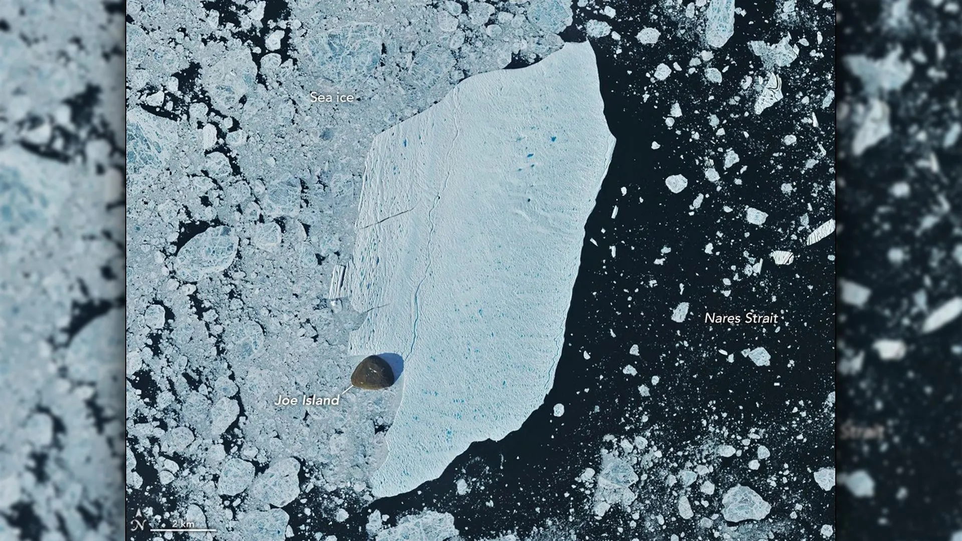
On August 23 and 24, the iceberg reached a critical navigational juncture: Joe Island, a small, rocky outcrop near the mouth of the fjord. Given that Joe Island sits directly in the path of calving events, it serves as a natural barrier that often acts as an "icebreaker" for incoming bergs. Historic data from 2010 showed that a similarly sized ice island shattered upon impact with this same outcrop. In a display of resilience, the 2026 ice island struck Joe Island but remained largely intact, an outcome that surprised even the experts tracking its progress.
Supporting Data: Dimensions and Historical Context
To understand the scale of the 2026 event, one must place it within the context of Petermann’s historical behavior. The 2026 ice island measured approximately 76 square kilometers (29 square miles) with a thickness estimated at less than 150 meters.
A Comparative Analysis
While massive, the 2026 event is not the largest on record for this specific glacier:
- 2010 Event: The most significant recent calving, producing an ice island of roughly 250 square kilometers.
- 2012 Event: A major fracture resulting in a 130-square-kilometer ice island.
- 2008 Event: A smaller, yet significant, break covering 31 square kilometers.
The 2026 event falls in the upper-middle tier of these historical milestones. However, the thickness of the Petermann ice islands—thinner and more fragile than the behemoths originating from Antarctica or other Greenland glaciers like Helheim—makes them unique. Their lack of substantial thickness means they are more susceptible to fragmentation via ocean currents, tides, and thermal degradation.
Future Risks
Researchers are not yet resting. As of late August 2026, two large, pre-existing rifts remained on the Petermann ice tongue. Based on current measurements, these rifts are projected to release further ice islands measuring 94 square kilometers and 84 square kilometers, respectively. The timing of these future events remains a "known unknown," as the internal mechanics of the glacier continue to shift under the influence of warming ocean waters.
Official Perspectives: The Role of Remote Sensing
The 2026 event serves as a testament to the power of modern satellite observation. Without the continuous monitoring provided by the ESA’s Sentinel-1 and NASA’s Landsat 9—specifically the Operational Land Imager (OLI)—such events would occur largely unobserved in the remote reaches of the high Arctic.
Scientific discourse, as shared through peer-reviewed updates and glacial study blogs, emphasizes the "life cycle" of a glacier. Glaciologists view calving as a normal, necessary process for an outlet glacier to shed mass. However, the frequency and scale of these events are the primary metrics for determining if a glacier is undergoing a transition into a state of chronic instability. By tracking these ice islands, scientists are effectively taking the pulse of the Greenland Ice Sheet.
Implications: Sea Levels and Maritime Safety
The significance of the Petermann Glacier extends far beyond the visual drama of a fracturing ice shelf.
The Freshwater Variable
As these ice islands drift south through the Nares Strait, they do not simply disappear. Their journey is one of gradual, persistent decay. As they melt, they release massive volumes of freshwater into the Arctic marine environment. This influx of freshwater alters local salinity levels, which can influence local currents and the biological productivity of the region.
Navigational Hazards
For the shipping industry, the release of an ice island of this magnitude is a logistical complication. As the berg breaks into smaller, more numerous pieces, it poses an increasing threat to maritime navigation and offshore infrastructure in the Arctic. The trajectory of the 2026 berg—moving southwest through the Nares Strait—is a path often monitored by local authorities to ensure that such "ice debris" does not drift into critical shipping lanes or threaten coastal communities.
The Long-Term Climate Outlook
The ultimate implication of the Petermann instability is the threat to the Greenland Ice Sheet as a whole. Petermann acts as a "gatekeeper," controlling the flow of ice from the interior of the island into the sea. If the ice tongue continues to thin and fracture, it may reduce the "back-pressure" that holds back the interior ice. A reduction in this resistance could theoretically accelerate the flow of the entire glacier, leading to a more rapid loss of ice mass and a subsequent, measurable increase in global sea levels.
As the 2026 iceberg continues its slow, fracturing descent through the Arctic waters, it carries with it a message from the North. It is a reminder that while the Arctic may seem distant, the dynamics governing its frozen expanse are inextricably linked to the global climate system. The international scientific community remains vigilant, watching the rifts on the Petermann Glacier, knowing that the next fracture is not a matter of "if," but "when."