
Oceanographers often cite a humbling statistic: we possess more detailed topographical maps of the Moon’s craters and the Martian plains than we do of the vast majority of Earth’s deep ocean floor. This disparity is perhaps nowhere more evident than in the Bismarck Sea, located north of Papua New Guinea. Despite being a region of immense geological volatility—defined by a complex network of faults, volcanic ridges, deep-sea rifts, and active subduction zones—it remains a "black hole" of cartographic knowledge. The extreme depths and treacherous currents of the region have long rendered traditional sonar mapping a logistical nightmare.
However, on May 8, 2026, the veil of mystery over the Central Bismarck Sea was violently lifted. A series of seismic tremors signaled the awakening of a long-dormant feature along Titan Ridge, triggering a multidisciplinary scientific response that is currently rewriting our understanding of underwater volcanism in real-time.
A Chronology of Discovery: From Seismic Silence to Satellite Vigilance
The first indications of unrest were purely mechanical. On May 8, regional seismometers detected a swarm of earthquakes, a classic precursor to magmatic movement. While seismic data can pinpoint a general area, it lacks the visual resolution to confirm an eruption. That confirmation arrived shortly thereafter, not from a research vessel, but from the silent sentinels orbiting hundreds of kilometers above the Earth.
The Initial Observations (May 9–11)
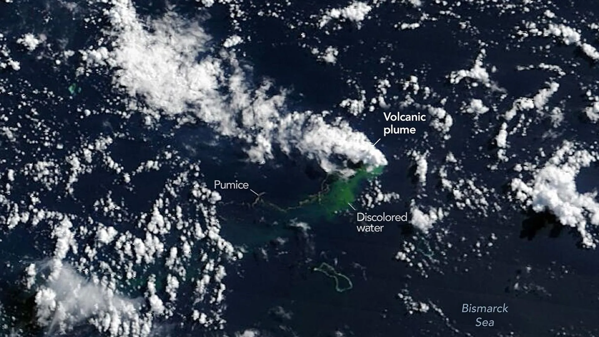
By May 9, NASA’s Aqua and Terra satellites, equipped with MODIS (Moderate Resolution Imaging Spectroradiometer) sensors, captured the first telltale signs: plumes of steam and volcanic ash billowing into the atmosphere. Simultaneously, the PACE (Plankton, Aerosol, Cloud, Ocean Ecosystem) satellite, designed to monitor ocean health, detected massive, irregular discoloration of the water, indicating a significant release of volcanic minerals and gases into the surrounding column.
As the event progressed, the data stream grew more granular. On May 10 and 11, the European Space Agency’s Sentinel-2 and the NASA/USGS Landsat 9 satellites provided high-resolution imagery of the surface activity. Analysts were particularly struck by false-color infrared imagery, which revealed intense thermal signatures, suggesting that the volcanic vent was far shallower than the bathymetric maps of the region—which suggest depths of several hundred meters—would imply.
Escalation and Thermal Mapping (May 12)
The intensity of the event was confirmed on May 12 by the VIIRS (Visible Infrared Imaging Radiometer Suite) instrument aboard the Suomi NPP satellite. The instrument identified a thermal anomaly covering approximately seven square kilometers, a massive footprint that indicated a significant volume of superheated material was reaching or nearly reaching the surface. "There must be a lot of hot material near the surface to generate so many thermal anomalies," noted Simon Carn, a volcanologist at Michigan Tech. "This suggests a fairly shallow eruption vent—much shallower than what’s implied by the existing bathymetry."
Supporting Data: The Physics of the Bismarck Eruption
The eruption is currently centered roughly 16 kilometers southeast of a site that witnessed a similar volcanic event in 1972. Despite the proximity, the exact identity of the erupting feature remains unknown. It is effectively a "ghost volcano," an underwater mountain that has likely existed for millennia without a name or a recorded history of activity.
The physical evidence gathered by the satellite fleet has painted a vivid picture of a vigorous, yet geographically contained, event. Observations confirm:
- Pumice Rafts: Extensive fields of floating volcanic rock have been tracked by commercial and government sensors as they drift across the Bismarck Sea. These rafts are key indicators of the eruption’s intensity and composition.
- Steam and Ash Vents: The presence of steam indicates that the magma is interacting directly with seawater, a process known as phreatomagmatic activity.
- Water Discoloration: The plumes of suspended sediment and mineral-rich discharge have allowed researchers to map the dispersion patterns of the eruption’s byproducts.
The "Spreading Center" Hypothesis
Volcanologists are currently debating the long-term outlook of the Titan Ridge event. Dr. Carn suggests that the eruption may remain relatively mild compared to the catastrophic 2022 Hunga Tonga-Hunga Ha’apai eruption. The reason lies in the tectonic setting.
"Spreading centers are associated with less explosive activity," Carn explained. "The most explosive eruptions are usually along subduction zones and involve large stratovolcanoes." The Titan Ridge event sits near the intersection of a transform fault and a back-arc spreading center. Because the crust is being pulled apart here—rather than being forced together as in a subduction zone—the magma tends to be more fluid and less prone to the explosive pressure buildup characteristic of the world’s most dangerous volcanoes.
Official Responses and the Prospect of a New Island
For NASA’s Jim Garvin, chief scientist at the Goddard Space Flight Center, the eruption represents a "once-in-a-career" opportunity. While the scientific community waits for a potential research vessel to be dispatched to the site, the reliance on orbital platforms has become the primary mode of investigation.
"The good news is that there are huge opportunities to explore and learn using both government and commercial satellite platforms already in orbit," Garvin said. The mission is now shifting toward long-term monitoring, specifically looking for the birth of a new landmass.
The "Island-naut" Initiative
Garvin and his colleagues are particularly interested in whether the volcanic material will accumulate enough volume to breach the surface. If a new island forms, it will become an immediate, high-priority laboratory for Earth and space scientists alike.
"We’re now eagerly waiting to see if a new island is about to be born—something that we’ve only rarely been able to observe with satellites as it happens," Garvin remarked. If land emerges, researchers plan to apply the "island-naut" framework—a term used for the interdisciplinary teams who study the rapid biological and geological colonization of new land. This would include observing how chemical weathering changes the volcanic rock, how seeds and wildlife arrive on the barren surface, and how erosion battles against the volcano’s growth.
Broader Implications: From the Bismarck Sea to Artemis IV
The curiosity surrounding this eruption extends far beyond geology. As humanity prepares to return to the Moon through the Artemis program, the study of ephemeral landscapes has taken on a new urgency.
"This new eruption could present an even better opportunity for ‘island-naut’ exploration as we prepare to return to the Moon with women and men via Artemis IV," Garvin stated. The logic is simple: by studying how an island is born, reshaped by rain and wind, and colonized by life, scientists gain a terrestrial analog for the geological and astrobiological processes they expect to encounter on lunar and Martian surfaces.
Furthermore, the uncertainty regarding the eruption’s duration remains a point of intense speculation. History in the Bismarck Sea offers little guidance; a 1972 eruption nearby concluded in just four days, while a 1957 event in the nearby St. Andrew Strait persisted for four years.
The Technological Frontier
To track the island’s potential development, Garvin is looking toward a new suite of radar-based satellites. The NASA-ISRO NISAR mission and the Canadian Space Agency’s RADARSAT Constellation are specifically designed to penetrate cloud cover and provide millimeter-level precision on surface changes. These tools will allow scientists to measure the "tuff cone" of the volcano, tracking its height, volume, and susceptibility to erosion in real-time.
As the Bismarck Sea continues to churn, the world is watching through the lenses of satellites—a reminder that while we have mapped the farthest reaches of our solar system, our own planet still hides mysteries of creation and destruction beneath its waves. Whether the Titan Ridge event results in a permanent addition to the map or a fleeting geological flicker, the data gathered in these coming weeks will serve as a foundational text for the next generation of planetary scientists.