
For years, seismologists operated under a set of established geological assumptions regarding the mechanics of "megathrust" earthquakes. The prevailing wisdom suggested that the most catastrophic ruptures—those capable of shifting entire tectonic plates—originated deep within the Earth’s crust, far beneath the ocean floor. However, the catastrophic 9.1 magnitude earthquake that devastated Japan in 2011 defied these models, leaving scientists to grapple with a mystery: How did a rupture gain such momentum that it shattered the seafloor itself?
A groundbreaking study published in the journal Science has finally provided the answer. By drilling into the deepest reaches of the Pacific Ocean, an international team of researchers has uncovered a "hidden feature"—a thin, remarkably slippery layer of clay-rich sediment—that acted as a lubricant for the 2011 disaster. This discovery not only demystifies the mechanics of the Japan Trench but fundamentally alters our understanding of how and where the world’s most destructive tsunamis are born.
The 2011 Catastrophe: A Re-examination
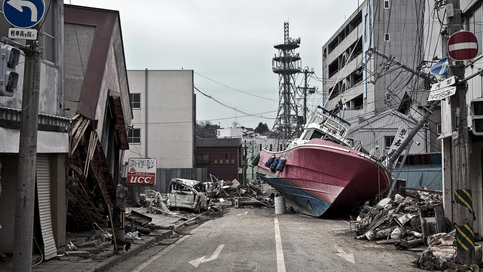
On March 11, 2011, the Tōhoku earthquake struck off the coast of Japan, triggering a tsunami that claimed nearly 20,000 lives and caused over $200 billion in infrastructure damage. While the earthquake’s magnitude was unprecedented in modern Japanese history, the scale of the resulting tsunami was what truly shocked the world.
The seabed shifted by a staggering 130 to 200 feet in the span of just six minutes. To put this into perspective, Christine Regalla, an associate professor at Northern Arizona University and co-author of the study, notes that this is equivalent to the entire distance between Los Angeles and San Francisco being displaced in the time it takes to brew a cup of coffee. "We’ve never seen anything like that in the time we’ve been observing earthquakes," Regalla stated. "Based on what we understood, we didn’t think that could happen."
Drilling into the Abyss: The Chikyu Expedition
To solve the mystery, an international consortium of scientists launched a high-stakes expedition aboard the research vessel Chikyu. The objective was ambitious: to drill approximately 26,000 feet into the ocean floor at the Japan Trench. This endeavor, which secured a Guinness World Record as the deepest scientific ocean drilling project ever completed, was designed to retrieve core samples of the fault zone.
The analysis of these samples revealed a 100-foot-thick layer of pelagic clay. This sediment, formed over millions of years through the slow accumulation of microscopic particles settling on the ocean floor, acted as a "tear line" for the tectonic plate. Unlike the surrounding rock, which is brittle and friction-heavy, this clay layer was remarkably soft and slippery.
The Mechanism of the Rupture
In a typical earthquake, the rupture initiates deep underground. For instance, the 2001 Nisqually earthquake in the Pacific Northwest occurred about 32 miles beneath the seafloor. In contrast, the 2011 Japan rupture reached to within just 15 miles of the seafloor.
"At the Japan Trench, the geologic layering basically predetermines where the fault will form," explains Patrick Fulton, an associate professor in Cornell University’s Department of Earth and Atmospheric Sciences. Because the clay layer was sandwiched between significantly stronger rock layers, it became an "extremely focused, extremely weak surface." This geological configuration allowed the earthquake’s rupture to propagate all the way to the trench, displacing massive volumes of water and creating the towering waves that decimated the Japanese coastline.
Implications for Global Seismic Hazard Assessment
The discovery of this clay layer is not merely a piece of academic trivia; it is a critical diagnostic tool for global seismic safety. The study confirms that the clay layer extends for hundreds of miles along the Japan Trench. This suggests that the region is inherently more vulnerable to "shallow slip" earthquakes—events where the rupture reaches the surface—than previous risk models accounted for.
The implications extend far beyond the Japanese archipelago. Because these weak sediment layers may exist in other subduction zones globally, researchers are now looking to re-evaluate the risk profiles of other coastal nations.
Why Tsunamis are Global Events
As Regalla emphasizes, seismic events of this magnitude are not localized tragedies. "An earthquake and tsunami in Japan doesn’t just impact people who live locally—it also impacts people at the ports and people who live across the ocean," she says.
Historical data supports this, as Hawaii’s most devastating tsunamis have historically originated from distant ruptures in Japan and Alaska. When a fault ruptures at the seafloor, it pushes the entire water column upward, sending energy across the Pacific basin at the speed of a jet plane. Understanding the geology of the trench is, therefore, a matter of international public safety.
Strengthening Infrastructure and Emergency Preparedness
For policymakers and urban planners, the findings from the Chikyu expedition represent a wake-up call. Japan is widely considered the gold standard for earthquake and tsunami preparedness, having invested billions in seawalls, seismic dampeners, and rigorous building codes. Yet, the 2011 event proved that even the most robust systems can be overwhelmed when the underlying geological hazard is underestimated.
The research team suggests several ways to translate these findings into concrete action:
- Updating Building Codes: Engineering standards can be refined to account for the potential of larger, shallower ruptures that produce greater ground acceleration.
- Infrastructure Resilience: Ports and critical coastal infrastructure can be reinforced to withstand the specific horizontal displacements associated with trench-level ruptures.
- Refined Evacuation Planning: By identifying which segments of the ocean floor are prone to these clay-lubricated ruptures, emergency managers can create more accurate tsunami inundation maps, ensuring that evacuation zones are appropriately sized.
The Road Ahead: Predicting the Unpredictable
While the discovery of the pelagic clay layer significantly narrows the margin of error in earthquake forecasting, researchers caution that we are still far from being able to predict the exact date and time of an earthquake. Instead, the focus is on "probabilistic seismic hazard analysis"—determining which segments of the world’s subduction zones have the potential to generate the largest, most disruptive events.
The shift in perspective is profound. Scientists have moved from viewing the fault line as a singular, uniform structure to seeing it as a complex, heterogeneous system defined by its weakest parts. The "tear line" discovered in the Japan Trench is now a focal point for further research in other high-risk zones, including the Cascadia Subduction Zone in North America and the Aleutian Trench.
As the scientific community continues to analyze the data from the Chikyu expedition, the collaboration between geologists, seismologists, and policymakers remains vital. The 2011 disaster was a tragedy of immense proportions, but the lessons it provided are now being synthesized into a global framework for resilience. By peering into the depths of the ocean floor, humanity is gaining the foresight necessary to navigate a planet that is, quite literally, shifting beneath our feet.
Ultimately, the goal is simple: to ensure that the next time a massive tectonic shift occurs, communities are better prepared, infrastructure is more resilient, and the human cost is drastically reduced. As Regalla poignantly noted, "We all need to gain a better understanding of where these events might happen in the future. Only then can we make emergency plans that will keep everyone safe."