
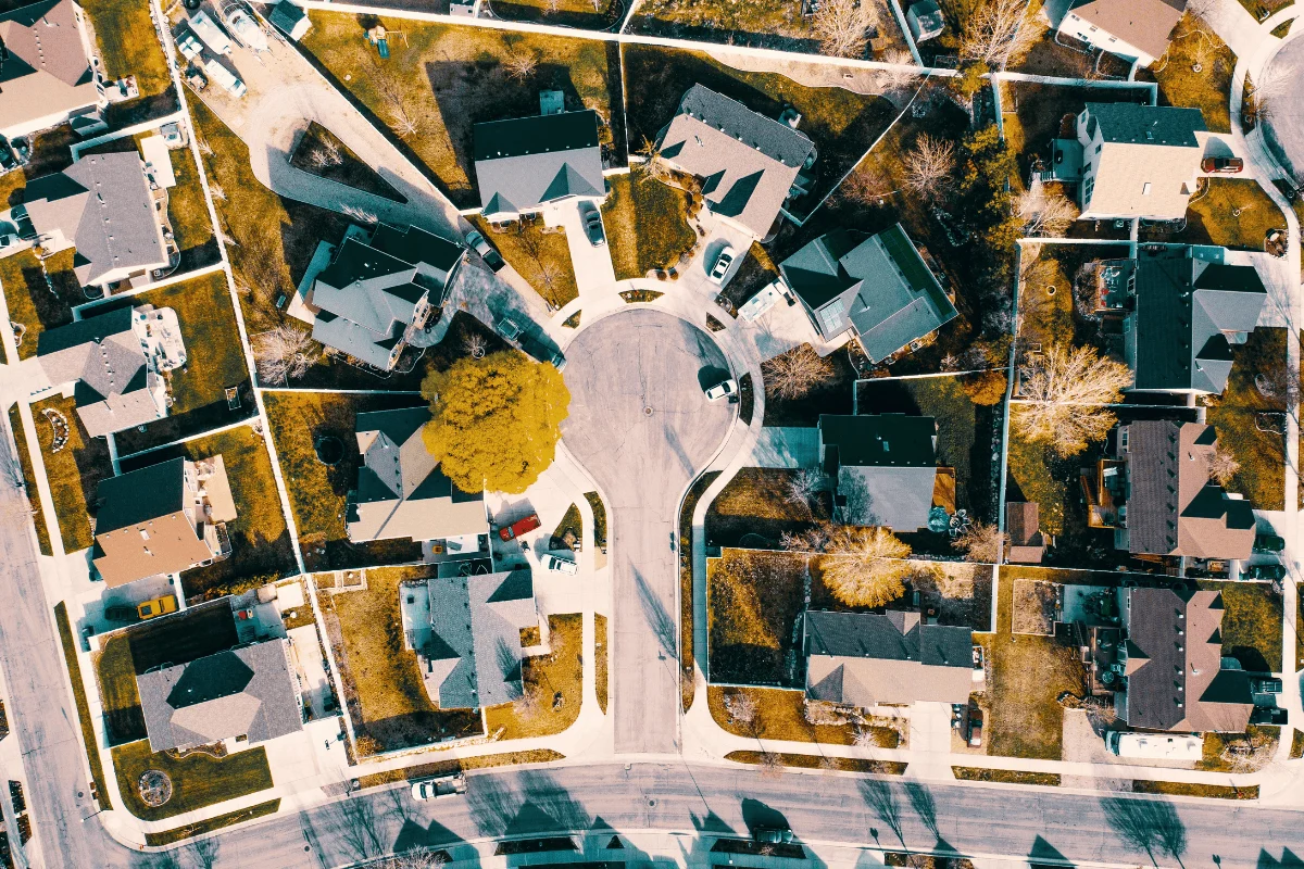
In the modern real estate market, a home is no longer just a collection of interior rooms and a curb-facing facade. Thanks to the ubiquity of high-definition drone photography, today’s buyers are looking at properties with a bird’s-eye view that reveals everything. A drone does not care about the price tag, the recent kitchen renovation, or the poetic descriptors in the listing copy. It sees the property as it truly exists: the state of the roof, the integrity of the driveway, the clutter behind the shed, and the exact relationship between the backyard and the neighbors.
Whether you are listing a cozy single-family home in Cincinnati or a sprawling estate in Houston, the drone acts as an unblinking witness. While this technology provides an unparalleled sense of scale and location, it also presents a significant challenge: without proper preparation and timing, an elevated perspective can inadvertently make a high-quality property look neglected or disorganized.
The Unfiltered Eye: Why Aerial Perspectives Demand Perfection
The primary utility of aerial real estate photography is its ability to contextually place a home within its environment. It shows potential buyers how the property sits in relation to schools, parks, water features, or neighborhood street layouts. However, this clarity is a double-edged sword. Ground-level photography allows for strategic framing that can hide minor imperfections; a drone, flying 100 feet overhead, removes that veil of secrecy.
The Hidden Clutter Factor
Before a homeowner even begins to consider the "best" time of day for a shoot, they must address the "eyesore" factor. Standard ground photography rarely captures the side passage beside the garage or the narrow strip of land behind a privacy fence. Conversely, a drone makes these areas a focal point. Items that a homeowner has learned to ignore—garden hoses, stray toys, overflowing recycling bins, or piles of lumber—become glaring beacons of neglect from above.
Alan Martin, an FAA-Certified Remote Pilot at Vantage Aerial Works, emphasizes the necessity of total property curation. "A fence can hide a trash can from the street and still leave it in plain view from a drone," Martin explains. "Before the shoot, put bins, hoses, toys, and lawn equipment in a garage or shed, clear the driveway, and tidy the patio. Send the photographer your address and point out the outdoor features you want buyers to see before choosing a shoot time."
The Chronology of Light: Choosing Your Window
Scheduling a drone shoot is a delicate balancing act between the property’s unique physical characteristics and the movement of the sun. There is no "one-size-fits-all" hour; instead, the timing must be dictated by the specific assets a seller intends to highlight.
The Golden Hour Dilemma
The "Golden Hour"—the period shortly after sunrise and shortly before sunset—is widely considered the holy grail of photography. The sun is low in the sky, casting long, dramatic shadows that add texture to masonry, grass, and tree lines. It creates a warm, inviting glow that makes a house feel like a "dream home."
However, professional pilots warn against defaulting to this time. "Golden hour isn’t automatically the best choice," says Martin. "If your key features, like a patio or a pool, are already in deep shadow due to tree cover or the house’s orientation, the golden hour will only exacerbate the issue."
Midday: The Clarity Play
When the sun is at its zenith, shadows are at their shortest. For properties where the primary objective is to showcase the lot size, the layout of a backyard, or the geometric cleanliness of a roofline, midday is often the superior choice. While the lighting may be "flatter" than the dramatic golden hour, it provides the most honest representation of the property’s footprint. It allows a buyer to see the full extent of the lawn without it being swallowed by the shadow of a two-story structure or a row of mature oaks.
Expert Analysis: Matching the Shoot to the Asset
The decision-making process for aerial photography should be treated as a strategic business move. It requires an understanding of light, geometry, and the specific selling points of the home.
Strategic Scheduling
Andrew Kobza, owner and FAA-licensed pilot at Professional Drone Solutions, advises sellers to look beyond the "pretty" light. "Be aware of the lighting at the time you request," he notes. "1-3 hours after sunrise and 1-2 hours before sunset will look dramatic, but shadows cast from homes, trees, light posts, and more then become a factor. Midday is a great general option if clarity is the goal."
To determine the ideal schedule, consider the following checklist based on property orientation:
- West-Facing Backyards: Morning shoots are often best to avoid the glare of the setting sun and to prevent afternoon shadows from turning a pool or deck into a dark, unappealing void.
- Shaded Front Elevations: If the front of the home is heavily forested, a late afternoon shoot might be necessary to capture the light as it finally breaches the tree line.
- Waterfront or Pool Properties: Consider the angle of the sun to avoid "blown out" reflections on the water, which can turn a blue pool into an unusable white square in a photograph.
Implications: The Role of Weather and Context
There is a pervasive myth among home sellers that only a "bluebird day" is suitable for photography. In reality, an overcast morning can be a secret weapon for real estate professionals.
The Case for Cloud Cover
Thin, uniform cloud cover acts as a massive diffuser, softening the light and eliminating the harsh, high-contrast shadows that can make a home look disjointed. For properties with complicated rooflines or dense, mature landscaping, an overcast day provides an evenness that direct, harsh sunlight cannot replicate.
Michael Summer, Director of ScoreDetect, offers a practical tip for sellers: "Book an overcast morning if you can. Midday sun throws hard shadows across rooflines that make photos look messier than the house actually is." By reducing the intensity of the light, the camera can capture more detail in both the highlights and the shadows, creating a more balanced, professional final product.
Building a Comprehensive Aerial Strategy
Ultimately, the goal of drone photography is to answer the questions that terrestrial photos leave behind. A well-constructed aerial shot list should be designed to inform the buyer, not just decorate the listing.
A Professional Shot List
To ensure the session is productive, work with your pilot to capture:
- The Contextual View: An elevated shot showing the home’s position within the neighborhood or its proximity to local landmarks (trails, water, parks).
- The Property Boundaries: A top-down or wide-angle shot that clearly defines the lot lines and fence boundaries.
- The Lifestyle Features: Close-up aerials of outdoor kitchens, pools, decks, and pergolas that show how they relate to the interior living space.
- The Condition Check: A clear, well-lit shot of the roof, which serves as a reassurance to buyers regarding the home’s maintenance history.
The Human-Drone Interface
Brandon Pierce, who operates Valley View Photo in the harsh light of Phoenix, Arizona, summarizes the necessity of preparation: "Aerial shots expose backyard clutter that ground-level photos don’t show. When you combine that with the right timing—avoiding the harshest sun or utilizing the soft glow of morning—you provide the buyer with a complete, transparent view of the asset."
Conclusion: The Property Dictates the Plan
The "best" time for real estate photography is a variable, not a constant. It is defined by the unique geography of the lot, the architectural style of the house, and the specific goals of the seller. By abandoning the obsession with "perfect" sunset shots and instead focusing on the clarity of the property, sellers can ensure their listing stands out.
The process is simple but rigorous: clear the clutter, identify the primary features, consult with your pilot about sun patterns, and remain flexible enough to pivot if the weather—or the shadows—dictate a change in plan. In the end, the drone is merely a tool. It is the human effort put into preparation and timing that turns a collection of aerial pixels into a compelling case for a sale.