
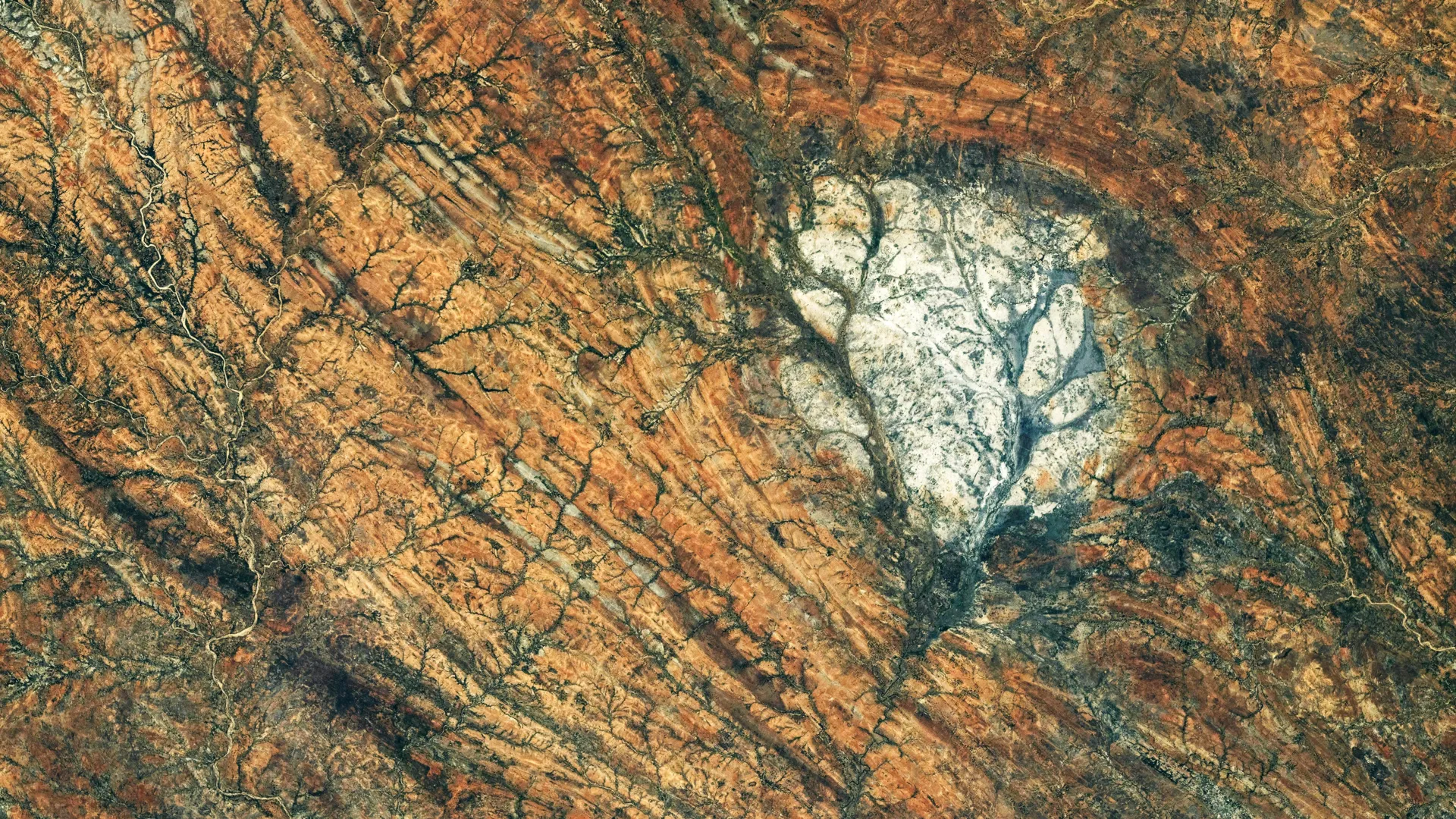
In the desolate, sun-bleached terrain of southern Madagascar, a striking geological anomaly catches the eye—not just of local observers, but of those orbiting 250 miles above the planet. A luminous, roughly circular patch of rock stands in stark contrast to the surrounding darkened, contorted landscape. This is the Saririaky anorthosite massif, a geological twin to the bright, reflective highlands that define the face of our Moon.
On August 28, 2026, a NASA astronaut aboard the International Space Station (ISS) captured a high-resolution image of this formation, providing a unique vantage point on a structure that serves as a terrestrial bridge to lunar history. While the rock—anorthosite—is a common sight on the lunar surface, its presence on Earth is a rare window into the violent, transformative processes that once shaped our supercontinents and, by extension, the rocky worlds of our solar system.
The Geological Identity of Anorthosite
Anorthosite is an intrusive igneous rock composed primarily of plagioclase feldspar. To the naked eye, it is distinctively pale, often appearing white or light gray. On the Moon, these rocks are the primary components of the lunar highlands, the bright, cratered regions that have fascinated humanity for millennia. When the Apollo missions returned samples from these lunar regions, geologists confirmed that the Moon’s crust was largely constructed from this material, dating back over four billion years to an era when the young Moon was likely a roiling ocean of molten magma.
On Earth, anorthosite forms in a vastly different, though equally profound, manner. As an intrusive igneous rock, it develops deep within the Earth’s crust, where magma cools at a slow, measured pace. This protracted cooling period allows the minerals within the molten material to organize into large, distinct crystals. While these formations are scarce compared to the Moon, they are found in select geological "hotspots" across the globe, including eastern Canada, Scandinavia, southern India, and the Saririaky region of Madagascar.
Chronology of a Continental Puzzle
The history of the Saririaky massif is a narrative written in stone, spanning at least 600 million years. According to geological research, the formation dates back to the late Precambrian, a time when the Earth’s surface was beginning to transition toward the complex conditions that would eventually support life.
The Assembly of Gondwana
The massif does not exist in isolation; it sits within a "ductile shear zone." Geologically, this refers to a region where rocks, under the immense heat and pressure of deep-crustal deformation, behave like high-viscosity fluids rather than brittle solids. They bend, stretch, and flow over geological time.
This specific region was forged during the assembly of Gondwana, the massive supercontinent that eventually stitched together modern-day Africa, India, Madagascar, Australia, and Antarctica. As these massive tectonic plates converged, the immense frictional heat and directed pressure transformed the landscape. The Saririaky formation was caught in this tectonic vice, recording the history of the Earth’s crust in its folded and sheared textures.
The Boudinage Phenomenon
One of the most compelling theories regarding the region involves a second anorthosite massif located approximately 60 kilometers to the north. Geologists suggest that these two formations were once a single, continuous body of rock. As the tectonic forces of the Gondwana assembly exerted pressure, the relatively rigid anorthosite was pulled apart, a process known as "boudinage." Much like taffy being stretched until it breaks into segments, the tectonic plates pulled the massif into distinct, separate bodies, leaving behind the scarred, linear patterns visible in the landscape today.
Supporting Data: Earth as a Laboratory for the Moon
The scientific value of the Saririaky formation transcends terrestrial geology. Because lunar samples are precious and limited, Earth’s anorthosite deposits serve as essential "analogue sites." By studying how these rocks behave under terrestrial conditions, scientists can refine their models for how the Moon’s crust solidified from the primordial magma ocean.
Comparative Planetology
The composition of anorthosite in places like Montana’s Beartooth Mountains or the Saririaky massif provides a ground-truth reference for lunar data. When researchers analyze the chemistry of terrestrial anorthosite, they gain insights into the fractionation processes—how different minerals separate as they cool—that governed the Moon’s early development.
If the Saririaky massif is indeed a product of the tectonic "boudinage" that occurred during the formation of Gondwana, it provides a terrestrial laboratory for studying how massive, crystalline structures react to planetary-scale collisions. This helps scientists understand not just the chemical makeup of lunar rocks, but the mechanical history of the Moon’s own crustal formation, which was subjected to intense bombardment and seismic activity in its infancy.
Implications for Future Exploration
The photograph taken by the Expedition 75 crew on August 28, 2026, is more than just a piece of photographic art; it is a diagnostic tool. Using a Nikon Z9 camera with a 400-millimeter lens, the ISS crew captured the subtle textural differences between the light-colored massif and the surrounding metamorphic rock.
These images allow geologists to map the "foliation trajectories"—the direction and flow of the rock layers—without the need for exhaustive ground-based mapping in one of the most rugged parts of Madagascar. By analyzing the way these rocks have been deformed, researchers can better understand the viscosity of the Earth’s lower crust during the Precambrian, a period that remains largely mysterious due to the recycling of the Earth’s surface through plate tectonics.
Furthermore, the study of terrestrial anorthosite ensures that when future lunar missions—such as the Artemis program—collect new samples, scientists have a robust framework for interpreting the data. We are essentially using the Earth as a decoder ring to unlock the history of the Moon.
Official Perspective and Technical Metadata
The photograph (ISS075-E-85249) serves as a primary asset for the Earth Science and Remote Sensing Unit at NASA’s Johnson Space Center. The image underwent standard processing to enhance contrast, allowing researchers to distinguish between the various mineralogical boundaries of the massif.
For the scientific community, the image is a reminder that the Earth is not merely a home, but a geological archive. Every mountain range, every exposed massif, and every shear zone is a testament to the forces that have shaped our planet over billions of years. When we look at the Saririaky massif, we are looking at a mirror of the Moon, a reminder that the same physical laws that cooled the lunar crust also sculpted the ancient supercontinents of our own world.
As NASA and international partners continue to look toward the Moon for future exploration, the lessons learned in the dusty, deformed rocks of Madagascar will remain a vital component of our quest to understand the origins of the rocky bodies in our cosmic neighborhood. The Saririaky formation stands as a testament to the interconnectedness of planetary evolution—a piece of the Moon, trapped in the bedrock of Earth, waiting to tell its story.