
As the 2026 fire season intensifies across Indonesia, a familiar and harrowing environmental phenomenon has returned. While wildfires are a recurring global challenge, those burning within Indonesia’s tropical peatlands represent one of the most stubborn, hazardous, and climate-altering disasters on Earth. Unlike conventional wildfires that race through timber and brush, peat fires are subterranean, smoldering in the dried-out, carbon-rich remains of ancient wetlands.
These fires are uniquely dangerous: they are notoriously difficult to extinguish, can persist for months, and serve as massive point-sources of greenhouse gases. As satellite imagery captures a landscape increasingly dotted with thermal anomalies, experts fear that 2026 could mirror the catastrophic fire seasons of the past, serving as a brutal "stress test" for the conservation measures implemented over the last decade.
The Anatomy of a Peat Fire: A Silent, Smoldering Crisis
To understand the severity of the situation in Indonesia, one must understand the nature of peat. Peat is a layer of organic material—decomposed vegetation and moss—that has accumulated over thousands of years. In its natural state, this soil is waterlogged, acting as a massive carbon sink. However, when these wetlands are drained or exposed to prolonged drought, the peat dries out, turning the ground itself into a highly combustible fuel source.
The Hidden Pollutant
Peat fires are significantly more polluting than traditional forest fires. According to recent research, these fires produce three times the fine particulate matter (PM2.5) of typical tropical forest fires. The chemical signature of this smoke is particularly toxic, containing:
- Sulfur Dioxide: Five times higher than standard biomass burning.
- Organic Carbon: Three times higher.
- Methane and Carbon Monoxide: Twice as much.
Because these fires burn underground at relatively low temperatures, they often lack the high, visible flames that make conventional fires easier to spot and suppress. They can linger beneath the forest floor for weeks or months, emerging in different locations as they follow veins of dry, combustible peat.
Chronology of a Developing Disaster
The 2026 fire season began with ominous environmental indicators. By August 2026, the National Oceanic and Atmospheric Administration (NOAA) confirmed that an El Niño event was not only present but strengthening. This climate pattern, which periodically warms the central and eastern Pacific Ocean, historically correlates with reduced rainfall across the Indonesian archipelago.
The August-September Escalation
- Early August 2026: Meteorological data indicated that roughly 90% of Indonesia received little to no rainfall. This severe, widespread drought set the stage for a rapid drying of the peatlands in Kalimantan, Sumatra, and Papua.
- August 31, 2026: Indonesia’s Ministry of Forestry, through the SiPongi fire-monitoring platform, recorded 946 hotspots across the country.
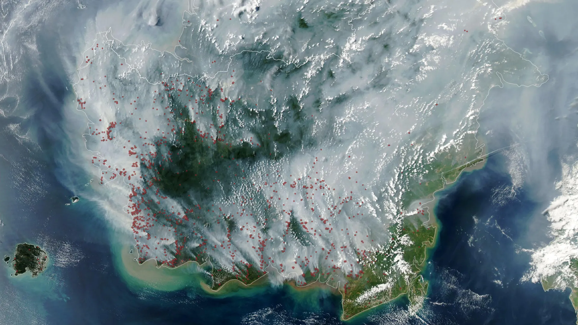
- September 1, 2026: NASA’s Aqua satellite, utilizing the MODIS (Moderate Resolution Imaging Spectroradiometer) instrument, captured an annotated map showing a dense cluster of red dots—each representing a thermal anomaly identified by sensor algorithms.
- Early September 2026: By the second day of the month, scientists estimated that the 2026 fires had already released roughly 10% of the total emissions produced during the entire 2015 crisis, signaling an aggressive start to the season.
Supporting Data: Comparing 2026 to the 2015 Benchmark
The comparison to the 2015 fire season is not merely academic; it is a point of deep concern for climate researchers. In 2015, Indonesia experienced one of the most destructive fire seasons on record. Over the course of three months, those fires emitted approximately 1.75 billion tons of greenhouse gas equivalents—a figure that exceeded the annual emissions of Japan.
The Climate Convergence
The intensity of the current season is driven by a "double-whammy" of climate phenomena. The presence of a strong El Niño is being compounded by a positive phase of the Indian Ocean Dipole. This combination creates a significant reduction in moisture, making the dry season significantly more pronounced.
Robert Field, a researcher at Columbia University and developer of the Global Fire Weather Database, notes that the current trajectory mirrors the alarming trends of 2015. "The strong El Niño is making the dry season drier over the fire-prone parts of the country and exacerbating burning—just as we anticipated it would," Field stated. He warns that while surface fires are a primary concern, the real danger remains the underground spread, which will likely continue until the onset of the monsoon rains, typically in October or November.
The "Blind Spot": Challenges in Satellite Monitoring
While modern technology allows for near-real-time monitoring via the MODIS and VIIRS (Visible Infrared Imaging Radiometer Suite) instruments, satellite technology is not a panacea.
The Paradox of Smoke
There is a cruel irony in satellite-based fire tracking: the more intense the fire, the harder it is to see. Thick, heavy smoke plumes and cloud cover frequently obscure the view of the forest floor, masking the scale of the destruction. Furthermore, because these fires often burn beneath the canopy or deep underground, standard sensors frequently fail to capture the full extent of the heat signature.
Mark Cochrane, an ecologist at the University of Maryland Center for Environmental Science, points out this observation gap. "The worst smoke events, paradoxically, can be the hardest to observe from space with MODIS and VIIRS," he explains. This limitation necessitates more advanced methods of observation, such as using shortwave infrared data from Landsat and Sentinel-2 satellites to detect lower-temperature understory fires.
Official Responses and Historical Context
The current crisis is not solely a result of natural climate cycles; it is deeply rooted in land-use decisions made over the past thirty years. During the 1990s, large-scale drainage projects—most notably the ill-fated "Mega Rice Project"—involved the construction of extensive canal networks. These canals effectively drained the water from peat swamps to make room for agriculture. While the goal was economic development, the result was a landscape far more susceptible to fire.
A Test of Resilience
Following the 2015 disaster, the Indonesian government and international partners launched several initiatives to restore the hydrological balance of these landscapes. These included:
- Canal Blocking: Installing dams in drainage canals to re-wet the peat and raise the water table.
- Firefighting Capability: Increasing the resources and training for local fire suppression units.
- Prevention Efforts: Implementing strict regulations against land clearing by burning and increasing community outreach.
The 2026 season acts as a "stress test" for these interventions. Shi Jun Wee, a graduate student at the University of Maryland, is working with NASA and MapBiomas to track the efficacy of these measures. By using Harmonized Landsat and Sentinel-2 (HLS) observations, researchers are attempting to gain a more granular understanding of whether these interventions are truly mitigating fire risk.
Implications: The Human and Global Cost
The immediate consequences of the 2026 fires are already disrupting life across Southeast Asia. In affected regions of Indonesia, authorities have been forced to close nine national parks to protect both the ecosystems and the public. In cities blanketed by haze, schools have shifted to remote learning to shield children from dangerous air quality, and air travel has faced significant delays.
The Necessity of Sustained Focus
The long-term implication, however, is global. Peatland fires are a "carbon bomb," releasing centuries of stored carbon into the atmosphere in a matter of weeks. The recurring nature of these fires, exacerbated by both climate change and historical land degradation, threatens to undo global efforts to reduce emissions.
As Mark Cochrane aptly puts it, the cycle of panic and forgetfulness must end. "People tend to focus on these fires during an El Niño and then forget about them," he says. "We need sustained focus, even during the years when they aren’t as bad, to solve this. These fires create a tremendous amount of emissions."
For Indonesia, the path forward requires a persistent, long-term commitment to wetland restoration and landscape management. As the 2026 fire season continues to test the limits of these efforts, the world watches, recognizing that the smoke rising over the archipelago is a warning signal for the health of the entire planet.