
In a climatic display that defied the fundamental nature of the world’s driest non-polar desert, northern Chile experienced a series of unprecedented winter storms throughout August 2026. The Atacama Desert, a region famously defined by its hyperaridity—where some weather stations have never recorded a single drop of rain—found itself blanketed in white as a succession of low-pressure systems pushed moisture from the Andes to the Pacific coast.
While snowfall is not entirely unknown in the high-altitude reaches of the Atacama, the scale, geographic breadth, and intensity of the August 2026 events have prompted atmospheric scientists to re-evaluate the resilience of the region’s infrastructure and the shifting influence of global climate patterns like El Niño.
The Meteorological Anomaly: A Chronology of the Storms
The transformation began in early August, but the climatic "event of the century" for the region unfolded in a two-act structure that left meteorologists and local authorities scrambling.
The Early August Prelude
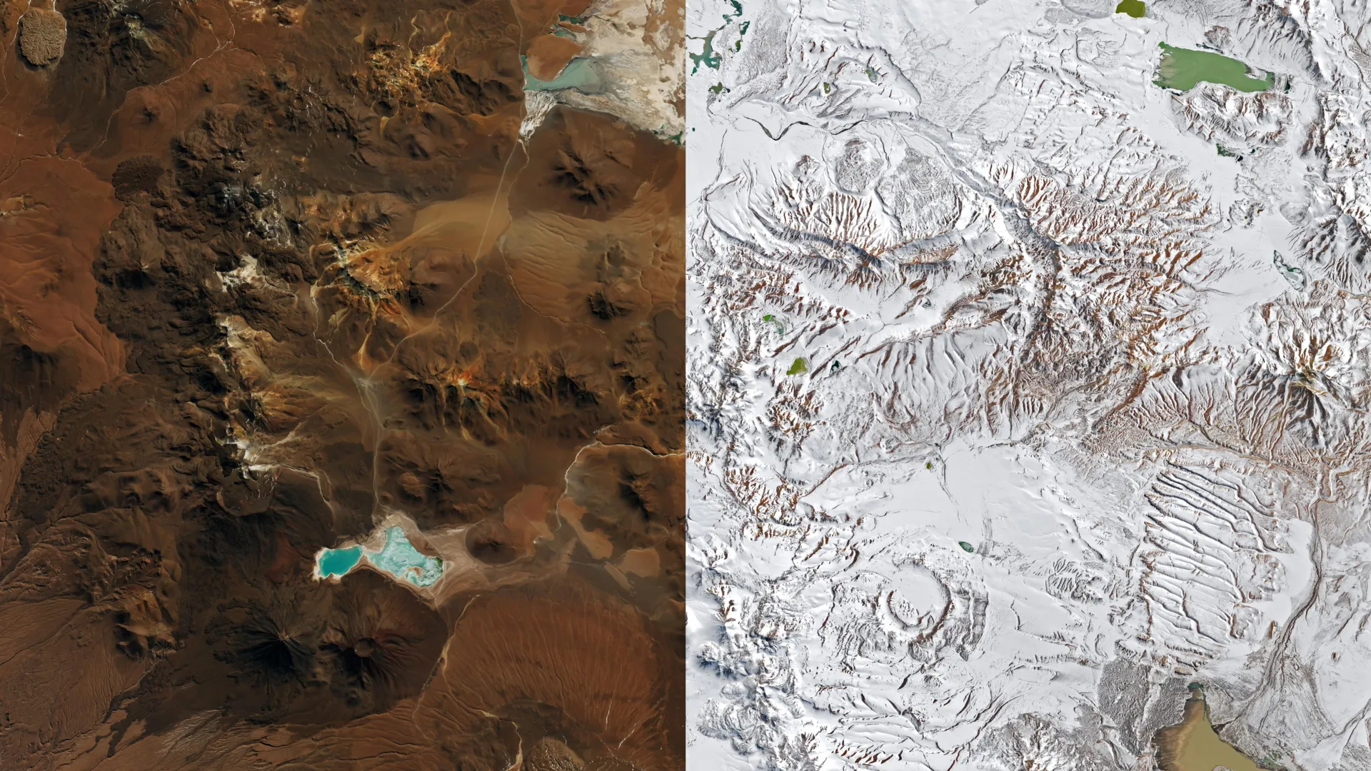
On August 6, 2026, satellite imagery provided by NASA’s Landsat 8 and 9 captured the initial impact of the first wave of winter storms. The Chajnantor plateau, a high-elevation expanse within the Altiplano-Puna volcanic complex, was transformed into a monochromatic landscape. This region, which serves as the site for the Atacama Large Millimeter/submillimeter Array (ALMA)—one of the most sophisticated astronomical observatories on the planet—was forced to pivot from scientific discovery to survival. As heavy snow accumulation and gale-force winds buffeted the plateau, ALMA engineers triggered emergency protocols, placing the massive radio telescope antennas into a protective "survival mode" to prevent structural damage.
The Late August Deluge
If the first week of August was a surprise, the events of mid-to-late August were historic. A second, more robust storm system developed that defied standard atmospheric models. By August 19, imagery from the MODIS instrument aboard NASA’s Terra satellite revealed a startling sight: a continuous blanket of snow stretching from the peaks of the Andes, across the hyperarid heart of the desert, and extending all the way to the Pacific coastline south of Antofagasta.
This second system did more than just coat the desert in snow; it brought heavy, persistent rain to the coastal regions, marking a radical departure from the desert’s typical meteorological profile.
The Science of the "Cutoff Low"
The mechanism behind these storms lies in a phenomenon known as a "cutoff low." Typically, the jet stream guides weather systems across the globe in a predictable path. However, a cutoff low occurs when a low-pressure system detaches from the main flow of the jet stream, becoming "stuck" over a region.
René Garreaud, a distinguished atmospheric scientist at the University of Chile, has been at the forefront of analyzing this event. According to Garreaud, while cutoff lows have been responsible for smaller, localized snow events in the past—most notably in 2011 and 2025—the 2026 event was fueled by a unique atmospheric configuration.
"This wasn’t a standard cutoff low," Garreaud explained. "This system broke away from an exceptionally large, elongated trough that stretched across a vast portion of the Southern Hemisphere. It acted like a siphon, drawing moisture from the Pacific and dumping it across the entire northern Chilean corridor, from the Andes to the shoreline."
This disrupted weather pattern allowed for moisture to be preserved and deposited at every elevation. The result was a rare trifecta of weather: snow in the mountains, freezing temperatures in the desert plateau, and torrential rain along the coast.
Statistical Shock: Three Days of Rain for a Decade
The true impact of the late August storm is best understood through the lens of local climatology. In the coastal city of Taltal, the precipitation totals were staggering. Within a 72-hour window, the city recorded nearly 40 millimeters (1.6 inches) of rain. To put this in perspective, that single event provided roughly 10 times the average annual rainfall for the city.
"We see these kinds of events only a few times, if any, per decade," Garreaud noted. The sheer volume of water overwhelmed local geography. In a desert where the soil is hard-packed and designed for heat rather than drainage, the ground could not absorb the moisture, leading to immediate surface runoff.
Official Responses and Human Impact
The environmental spectacle was accompanied by a humanitarian crisis. As the snow melted and the rain persisted, the National Disaster Prevention and Response Service (SENAPRED) was forced into high-alert status. The rapid accumulation of water on the desert floor, mixed with decades of accumulated dust and sediment, triggered massive mudflows and flash flooding.
The infrastructure of northern Chile, largely built to withstand earthquakes rather than water, suffered significant damage. SENAPRED reported that thousands of residents were directly affected by the flooding, with hundreds of homes sustaining major structural damage. The government declared a state of catastrophe in the northern provinces, facilitating the release of emergency funds and the deployment of military and civil rescue units to clear debris-clogged roads and restore power to isolated communities.
Beyond the urban centers, the impact on the scientific community was severe. Several major international observatories located along the coast were forced to suspend operations. The disruption was not merely a matter of safety for personnel, but a loss of precious observation time that ripples through the global astronomical community.
The "El Niño" Connection: A Pattern of Change
The August 2026 storms did not occur in a vacuum; they were the culmination of a meteorological season characterized by a strengthening El Niño. This climate cycle, which involves the warming of ocean surface temperatures in the equatorial Pacific, fundamentally alters global weather patterns.
Garreaud points to two specific shifts caused by the 2026 El Niño that set the stage for the disaster:
- The Weakening of the Subtropical High: Normally, a high-pressure system sits off the coast of Chile, acting as an atmospheric "shield" that blocks moisture and keeps the Atacama arid. El Niño weakens this high, lowering the barrier.
- The South Pacific Blocking High: As the subtropical high weakens, a "blocking high" often forms further south in the Pacific. This forces the Southern Hemisphere storm track to shift equatorward.
This shift essentially "pushed" the storm track toward northern Chile, allowing powerful, moisture-laden systems that would normally dump their rain in central or southern Chile to strike the northern deserts instead. This followed a significant, high-impact weather event in July 2026, which had already alerted scientists to the fact that the region was entering a "wetter" phase of its climate cycle.
Implications: The Future of the Atacama
The events of August 2026 serve as a stark reminder of the volatility inherent in climate systems. While the Atacama is famous for its dryness, it is not immune to the impacts of a warming planet and changing ocean temperatures.
Infrastructural Resilience
The damage caused by mudflows and flooding highlights a critical vulnerability in Chile’s northern infrastructure. Urban planning in these arid zones must now account for the possibility of extreme precipitation. This includes the development of better drainage systems, flood-resistant housing, and more sophisticated early-warning networks for residents living in high-risk zones.
Scientific Continuity
For the scientific community, the 2026 event poses a long-term challenge. As astronomical observatories become more complex, they require more robust, climate-proof housing. The decision by ALMA to move to "survival mode" was a success in terms of hardware protection, but it underscores the need for continued investment in automated, weather-hardened observation technology.
A New Baseline?
Perhaps the most pressing question for atmospheric scientists is whether these storms represent a permanent shift. While one season does not constitute a trend, the increased frequency of "cutoff low" events over the last 15 years suggests that the Pacific-Andean climate feedback loop is becoming more unstable.
As the world continues to monitor the progression of El Niño, the people of the Atacama are left to grapple with the aftermath of a winter that was, quite literally, a once-in-a-generation event. The desert has proven that even its most stable characteristics are subject to change, and that in the face of shifting global climate patterns, the "driest place on Earth" may no longer be as predictable as history would suggest.