
Rain is one of nature’s most complex paradoxes. It is simultaneously a life-giving force that sustains our ecosystems and a destructive power capable of reshaping landscapes through floods, landslides, and erosion. For the prospective homebuyer, the character of a city’s climate is no longer just a matter of preference—it is a critical component of financial planning and risk management. As shifting global weather patterns alter historical norms, understanding the distinction between "gloomy" cities and "high-precipitation" regions has become an essential step in the modern migration journey.
Main Facts: The Geography of Precipitation
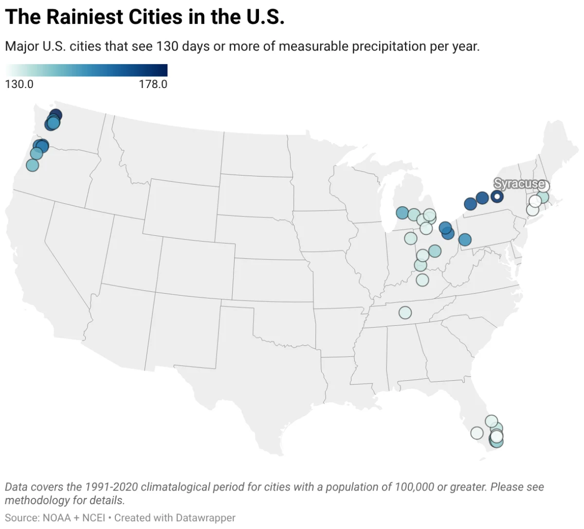
When analyzing the rainiest cities in the United States, data reveals a stark divide between regions characterized by persistent, low-intensity gloom and those subject to explosive, high-volume weather events.
The Pacific Northwest and the Great Lakes region dominate the rankings for the highest frequency of rainy days. In these areas, residents often trade long periods of sunshine for an almost constant, light-to-moderate mist that can stretch across the fall, winter, and spring months. Conversely, the Southern United States experiences a different reality. While these cities may see fewer "rainy days" by the calendar, they often contend with significantly higher total annual precipitation volumes, driven by tropical storms, hurricanes, and intense seasonal thunderstorms.
Chronology: How Weather Patterns Have Shifted
The history of American precipitation is in a state of flux. Since 1901, global precipitation has increased by an average of 0.08 inches per decade, but the continental United States has seen a more pronounced uptick of 0.17 inches per decade.
This is not merely a matter of more rain; it is a matter of how the rain falls. Historically, regions like the Pacific Northwest were defined by days-long, gentle drizzles. Today, meteorologists observe a distinct shift toward "flashier" weather. Even in traditionally "gloomy" cities like Seattle, the nature of the rain is changing, with a higher frequency of intense, short-duration downpours replacing the steady, light showers of the past.
Similarly, the Great Lakes region continues to be defined by "lake-effect" precipitation. As cold, dry air masses move over the warmer waters of the lakes, they pick up massive amounts of moisture and heat, which are then deposited as rain or snow on the downwind shores. This phenomenon, which has shaped the climate of cities like Buffalo and Syracuse for centuries, is becoming increasingly erratic as lake temperatures fluctuate more significantly than they did in previous decades.
Supporting Data: Where the Clouds Never Part
To understand the landscape of American rainfall, one must look at both frequency and volume. The following tables delineate the cities where the umbrella is a permanent fixture of daily life.
The Most Consistent "Gloomy" Cities
These cities are ranked by the average number of days per year with measurable precipitation, highlighting areas where the sky is rarely clear for long.
| City | Average Annual Rainy Days | Average Annual Precipitation |
|---|---|---|
| Everett, WA | 178 | 33.4" |
| Syracuse, NY | 174 | 39.9" |
| Tacoma, WA | 168 | 42.0" |
| Rochester, NY | 168 | 35.1" |
| Buffalo, NY | 166 | 40.7" |
| Vancouver, WA | 163 | 42.3" |
| Akron, OH | 160 | 41.6" |
| Hillsboro, OR | 159 | 35.9" |
| Cleveland, OH | 158 | 41.0" |
| Portland, OR | 157 | 36.9" |
The High-Volume "Storm" Cities
These cities, located primarily in the South, may see fewer rainy days but experience significantly higher total rainfall depths due to tropical systems and severe convective storms.
| City | Average Annual Precipitation | Average Annual Rainy Days |
|---|---|---|
| Hialeah, FL | 72.9" | 141 |
| Miami, FL | 67.4" | 141 |
| Mobile, AL | 67.1" | 117 |
| Metairie, LA | 63.4" | 115 |
| Lafayette, LA | 62.8" | 118 |
| Beaumont, TX | 62.1" | 110 |
| Pembroke Pines, FL | 62.0" | 148 |
| Baton Rouge, LA | 61.9" | 114 |
| West Palm Beach, FL | 61.8" | 137 |
| Fort Lauderdale, FL | 61.0" | 131 |
Data sourced from NCEI/NOAA 30-year averages (1991-2020).
Official Responses: Climate Risk and Mitigation
Government agencies and climate scientists have responded to these changing patterns by updating flood maps and emphasizing "orographic lifting" and other meteorological factors that contribute to extreme events. In Hawaii, for example—home to the wettest spots on the planet like Mount Waiʻaleʻale and the Big Bog—the orographic effect is so pronounced that specific windward slopes see nearly constant saturation.
National weather authorities now categorize these areas not just by rainfall, but by the risk intensity of that rainfall. For prospective residents, this means that the "climate risk" of a property is now just as important as its proximity to schools or job centers. The National Oceanic and Atmospheric Administration (NOAA) emphasizes that as the planet warms, the atmosphere’s capacity to hold water increases, leading to higher-intensity, more unpredictable storm events that can overwhelm existing infrastructure.
Implications for Homebuyers and Investors
The decision to relocate to a rain-heavy city carries significant long-term financial implications. Perhaps the most critical is the escalating cost and decreasing availability of property insurance.
1. The Insurance Landscape
In flood-prone areas, traditional homeowner insurance policies often exclude water damage, necessitating separate flood insurance. As extreme weather events become more frequent, the "risk-based pricing" of these policies is surging. In some regions, insurance providers are withdrawing entirely, leaving homeowners to rely on government-backed programs or face the high costs of self-insuring.
2. Infrastructure and Maintenance
Homeowners in high-precipitation zones must be proactive. Maintaining clear gutters, installing high-capacity sump pumps, and ensuring proper drainage (or grading) away from the foundation are not optional maintenance items—they are essential protective measures. Moving valuable documentation and physical assets to higher levels within a home is a recommended strategy for those in high-risk zones.
3. Climate Literacy in Real Estate
Modern real estate platforms have adapted to this reality. Tools like Redfin’s climate risk assessment allow users to view a property’s projected susceptibility to flooding, wind, and extreme weather before they ever step foot in the home. By utilizing data from organizations like First Street (MSCI) and The Weather Company, buyers can make data-driven decisions that account for the next 30 years of potential weather changes.
4. Urban Transformation
Interestingly, many of these rain-heavy, "gloomy" cities are currently experiencing an urban renaissance. Often overlooked in favor of sunny, coastal hubs, cities in the Rust Belt and the Pacific Northwest are proving to be more affordable and more resilient in terms of housing market competition. Buyers are increasingly weighing the trade-off: a more consistent, cooler, and rainier climate in exchange for better affordability and a slower, more stable cost of living.
Conclusion: Living with the Rain
Whether you are drawn to the moody, mist-covered hills of the Pacific Northwest or the tropical intensity of the Gulf Coast, rain is a defining characteristic of your environment. It shapes the local culture, the regional architecture, and the very health of the ecosystem.
However, it also demands respect. As climate change continues to alter the frequency and intensity of precipitation across the United States, the smartest move a buyer can make is to research the specific climate risks of their prospective city. By understanding the difference between a rainy season and a flood zone, you can move with confidence, ensuring that your home remains a sanctuary regardless of what the forecast holds.