
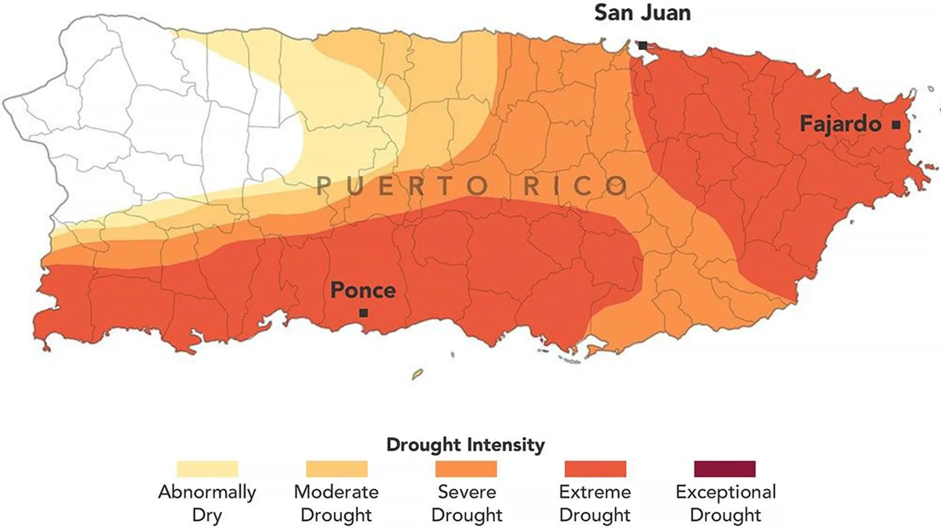
By late August 2026, the lush landscapes of Puerto Rico—an island synonymous with tropical rainfall and verdant mountains—had been transformed into a stark map of cracked earth and dwindling reservoirs. What began as a promising, wet spring in the U.S. Caribbean shifted with alarming speed into a climate crisis, prompting federal disaster declarations and emergency water rationing. The current drought, which has gripped 44 percent of the territory in "extreme" conditions, marks one of the most significant environmental challenges to hit the island in recent years, testing both the resilience of its residents and the precision of modern climate modeling.
The Rapid Onset: From Abundance to Aridity
The narrative of 2026 began with hope. According to the National Integrated Drought Information System (NIDIS), the late winter and early spring months were characterized by precipitation levels that were, in many regions, above the historical average. For farmers and city planners, the year looked set to be one of agricultural bounty and water security.
However, the transition from May to August proved to be a meteorological anomaly. By mid-May, the rains that typically signal the beginning of the wet season failed to materialize with their usual intensity. By mid-July, the data was clear: most of the island had received less than 60 percent of its normal rainfall. In the southern and southwestern sectors, the deficit was even more severe, with some areas recording less than 20 percent of their expected precipitation.
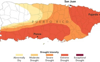
This resulted in a rainfall deficit of 3 to 6 inches (76 to 152 millimeters) in a matter of weeks. The change was abrupt and absolute; three months prior, the U.S. Drought Monitor recorded zero percent of the island in drought status. By late August, that number had surged to approximately 75 percent, with the most severe "extreme drought" category consuming nearly half the island.
The Anatomy of an Assessment: NASA’s Enhanced Role
Central to the understanding of this crisis is the U.S. Drought Monitor, a collaborative effort involving the National Drought Mitigation Center at the University of Nebraska-Lincoln, the U.S. Department of Agriculture (USDA), the National Oceanic and Atmospheric Administration (NOAA), and NASA.
While NASA has contributed Earth-observation data to this project for years, 2026 marked a pivotal shift in the agency’s involvement. For the first time, NASA scientists were integrated into the core team responsible for producing the weekly drought assessments. David Mocko, a senior research scientist at NASA’s Goddard Space Flight Center, and Jonathan Case of the Marshall Space Flight Center, have become the first NASA experts to lead the production of these weekly maps.
The incorporation of satellite-based metrics has allowed for a much more granular view of the disaster. As Mocko explained, the Drought Monitor now relies on a sophisticated tapestry of data: satellite estimates of soil moisture, real-time weather measurements, streamflow gauge readings, and data from deep-well monitoring. This data proved crucial for the August 18 and August 25 updates, which mapped the rapid expansion of the drought and provided the evidentiary basis for federal intervention.
A Perfect Storm of Heat and Hydrological Decline
The drought’s intensity was compounded by an unforgiving heatwave. San Juan, the capital city, recorded one of its warmest Julys in meteorological history. These high temperatures served to accelerate the evaporation of surface water and depleted soil moisture at an accelerated rate, leaving vegetation withered and stressed.
The hydrological impact was perhaps most visible in the island’s river systems. Streamflow in critical waterways, such as the Rio Fajardo in northeastern Puerto Rico, plummeted to record lows. When combined with the lack of precipitation, the drop in river levels triggered an immediate crisis for the reservoirs that supply water to millions. By early August, the government was forced to implement water rationing programs in several municipalities, turning off the taps for hours at a time to preserve what little water remained.
The Human and Economic Toll: Agriculture and Infrastructure
The implications of this drought extend far beyond municipal water taps; they are deeply felt in the agricultural sector, the backbone of the island’s rural economy.
Farmers have reported significant disruptions to the growth cycles of vital crops. Fruit and cacao trees, which require consistent moisture to thrive, have shown signs of premature wilting and stunted fruit development. The island’s signature coffee and banana plantations have also faced substantial losses, with many plants failing to yield a harvestable crop under the persistent heat.
For ranchers, the situation is equally dire. The lack of rain has halted the growth of pastures, forcing producers to contend with dwindling hay supplies. As grass dies back, the cost of importing supplemental feed has skyrocketed, placing many small-scale livestock operations in financial jeopardy.
Furthermore, the drought has shone a harsh light on Puerto Rico’s aging water infrastructure. While the weather is the catalyst, observers have noted that chronic leaks and system inefficiencies have exacerbated the impact of the shortages, making a bad situation significantly worse for the average citizen.
Official Responses and Federal Intervention
The severity of the situation did not go unnoticed by leadership in San Juan or Washington. In late July, the Governor of Puerto Rico declared a formal state of emergency, a move designed to unlock emergency funding and allow for greater flexibility in water management.
By late August, the U.S. government responded with a formal drought disaster declaration covering more than two dozen cities and towns. This declaration, approved by the USDA, is a critical mechanism for relief. Under the "fast track" process enabled by the U.S. Drought Monitor maps, these designations allow federal officials to direct emergency assistance, low-interest loans, and technical resources to farmers and ranchers struggling to mitigate their losses.
The Drought Monitor maps, which have been published consistently since 1999, have once again proven their utility as a primary decision-making tool. By visualizing the "Extreme" (dark orange) and "Exceptional" drought zones, policymakers can allocate resources with surgical precision, ensuring that aid reaches the hardest-hit areas in the eastern and southwestern regions of the island.
Looking Forward: A Climate in Flux
As September 2026 begins, the people of Puerto Rico remain in a state of cautious waiting. While historical patterns suggest that the peak of the wet season should eventually provide relief, the unpredictability of the current season serves as a sobering reminder of the changing climate in the Caribbean.
The integration of NASA scientists into the Drought Monitor team is a long-term investment in preparedness. By combining satellite data with ground-level intelligence, researchers hope to improve the predictive capacity for these events, allowing for earlier warnings and more proactive water management.
For now, the focus remains on conservation and recovery. The 2026 drought will likely be studied for years to come—not just as a failure of rainfall, but as a case study in how quickly a modern society can be forced to adapt when its most basic natural resource begins to vanish. The resilience of the Puerto Rican people is currently being tested by the landscape itself, and the road to recovery will require a sustained commitment to infrastructure reform and a continued reliance on the best scientific data available to navigate an increasingly volatile climate.