
By Science & Environment Desk
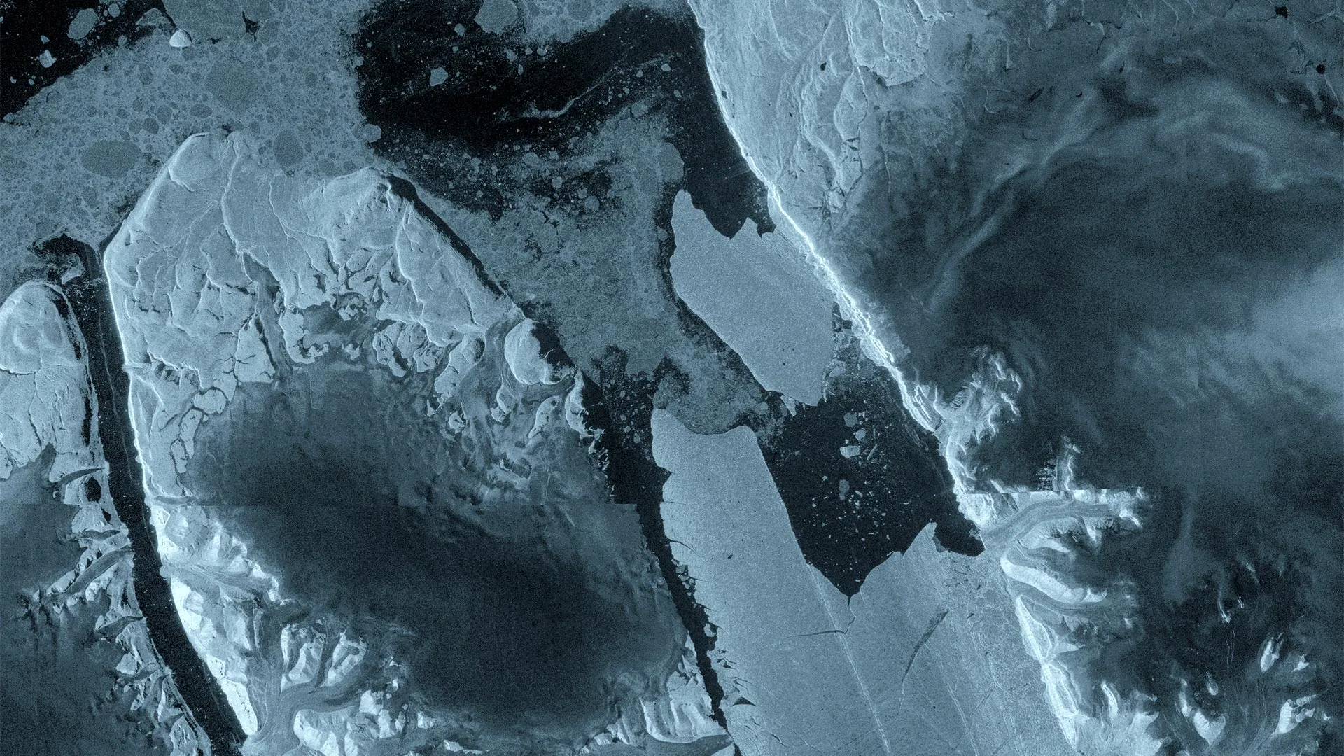
In a stark illustration of the rapid transformation occurring across the Earth’s polar regions, a gargantuan section of Greenland’s Petermann Glacier has fractured and detached from its floating ice tongue. The event, confirmed by the European Space Agency’s (ESA) Copernicus Sentinel-1 mission, occurred on August 4, 2026, releasing a 76-square-kilometer "ice island" into the northern seas. This calving event—the largest recorded in the Arctic since 2020—serves as a high-latitude barometer for the shifting dynamics of the cryosphere in an era of global climatic change.
Main Facts: A Colossus Adrift
The newly formed iceberg is a tabular mass of frozen history, estimated to be up to 150 meters thick and covering an area roughly equivalent to the island of Manhattan. This massive block of ice represents the most significant loss of floating ice from the Petermann Glacier since the notable events of 2012.
For years, the Petermann Glacier has been closely monitored by an international consortium of researchers, including teams from the University of Ottawa (Canada), the Universities of Stirling, Lancaster, and Leeds (UK), and the Canadian Ice Service. Their work, bolstered by the ESA’s FutureEO ARCTEX project, has transformed our understanding of how such massive ice shelves behave as they face the dual pressures of warming ocean currents and atmospheric shifts.
Chronology of a Fracture: From Stress to Separation
The detachment of this ice island was not a sudden, unpredictable anomaly, but the culmination of months of structural degradation. Sentinel-1 radar data provided a front-row seat to the slow-motion collapse.
- April 2026: Interferometric observations first signaled distress within the floating ice tongue. Scientists identified significant deformation and internal fracturing, suggesting that the structural integrity of the shelf was reaching a critical threshold.
- August 3, 2026: Radar imagery captured a dramatic deterioration pattern manifesting along the central axis of the ice tongue. The stress on the ice was now visually evident, with fissures deepening and widening at an accelerated rate.
- August 4, 2026: The tension reached a breaking point. Within 24 hours of the previous observation, the 76-square-kilometer section cleanly separated from the glacier’s eastern flank, drifting away as an independent ice island.
This precision in tracking was made possible by the unique capabilities of the Sentinel-1 satellite constellation, specifically the tandem phase of the Sentinel-1C and newly commissioned Sentinel-1D satellites. By utilizing one-day repeat synthetic aperture radar (SAR) observations, researchers were able to witness the "near-real-time" propagation of cracks and the mechanical response of the glacier to ocean tides—a feat of observational science that would have been impossible only a decade ago.
Supporting Data: The Power of Sentinel-1
The success of this monitoring operation highlights the indispensability of space-based radar technology in polar research. Unlike optical sensors, which are frequently thwarted by the persistent cloud cover and the long, dark winters of the Arctic, Sentinel-1 uses radar pulses that penetrate clouds and operate regardless of solar illumination.
"The changes we observed on Petermann Glacier were occurring very rapidly in the lead-up to the iceberg calving event," said Molly Hammond, a PhD student from the University of Leeds, who processed the complex data. "It was incredibly exciting to monitor the crack propagation with interferometry in near-real-time. This has demonstrated the incredible value of one-day repeat synthetic aperture data."
The interferometric data allowed scientists to quantify the movement of the ice shelf’s surface with sub-centimeter precision, revealing how the glacier was "flexing" in response to the buoyancy of the ocean. This data serves as a vital input for glaciological models, helping scientists understand the mechanical feedback loops that precede catastrophic calving events.
Official Responses and Scientific Perspective
The scientific community has treated the event as a unique, albeit concerning, opportunity to advance the study of polar dynamics. While tabular icebergs are common in the Antarctic, they are far rarer in the Arctic, making the Petermann event a rare case study for glaciologists.
Adam Garbo, a PhD researcher from the University of Ottawa, noted the significance of the event in the context of the glacier’s history. "Petermann Glacier has long been one of Greenland’s largest remaining ice tongues. We’ve anticipated this break for years, and seeing it finally happen is remarkable. It’s a powerful reminder of how quickly these systems can change."
Anna Crawford of the University of Stirling emphasized the broader implications of the study. "By studying Arctic ice islands, we will gain knowledge that can be transferred across polar regions. This is critical for understanding how the calving and deterioration of ice islands impact glacier dynamics, sea-level rise, and the ocean environment."
From the European Space Agency, Martin Wearing reflected on the systemic importance of the mission. "Satellite missions such as Sentinel-1 provide the systematic, long-term observations needed to track these changes, helping scientists better understand the processes driving calving and the wider impacts on the polar environment, and ultimately the Earth system as a whole."
Implications: A Future of Continued Instability
The August 4 event is likely not the final chapter for the Petermann Glacier. Researchers have identified two additional ice islands, measuring approximately 97 and 87 square kilometers respectively, that appear primed to detach. As existing rifts continue to propagate across the remaining ice tongue, the stability of the entire formation remains in question.
The Risk to Navigation and Infrastructure
Beyond the academic interest, the calving event carries tangible risks. The Canadian Ice Service and other international bodies are actively monitoring the drift trajectory of the new ice island. Large tabular icebergs act as significant hazards to maritime navigation and offshore infrastructure.
As these ice masses drift into open waters, they undergo a slow, unpredictable process of fragmentation. Smaller "growlers" and "bergy bits" break off from the main mass, creating a field of hazards that can persist for years. For shipping routes in the Northwest Passage and surrounding regions, these icebergs necessitate constant vigilance and sophisticated tracking.
Environmental and Climate Impacts
The broader implications involve the role of the Petermann Glacier as a "gatekeeper" for the Greenland Ice Sheet. When a floating ice tongue breaks away, the back-pressure that it exerts on the upstream glacier is reduced. This can lead to increased ice flow speeds from the interior of the ice sheet toward the ocean, contributing to global sea-level rise.
Furthermore, the introduction of massive quantities of freshwater into the marine environment—as these ice islands melt—can alter local ocean salinity and stratification, potentially affecting marine ecosystems and localized circulation patterns.
Conclusion: A Window into a Changing Arctic
The calving at Petermann Glacier stands as a testament to the accelerating pace of change in the Arctic. As satellite technology provides higher-resolution, more frequent windows into these remote environments, the data confirms a trend of increasing volatility.
The international research team, supported by the ARCTEX project, plans to continue their tracking efforts using a combination of satellite imagery, aerial surveys, and oceanographic data. Their work is more than just an observation of a single event; it is a vital effort to decode the complex, interconnected processes of the Earth’s climate system. As the Arctic continues to warm at a rate significantly higher than the global average, the "ice islands" of today may well be the harbingers of a transformed ocean landscape for tomorrow.