
For over a century, the Grand Canyon has served as the ultimate geological textbook, a vivid, mile-deep cross-section of Earth’s history. Yet, for all its majesty, the canyon has long guarded a profound secret: the "Great Unconformity," a baffling, billion-year-long gap in the rock record where layers of earth appear to have vanished into thin air.
Now, a groundbreaking study published in the journal Geology has finally provided a missing piece to this puzzle. Researchers have uncovered evidence that the deepest, oldest rocks of the Grand Canyon were not initially exposed by the Colorado River, but rather by an enormous, long-lost cliff system that once defined the perimeter of North America nearly a billion years ago.
The Genesis of a Geological Giant
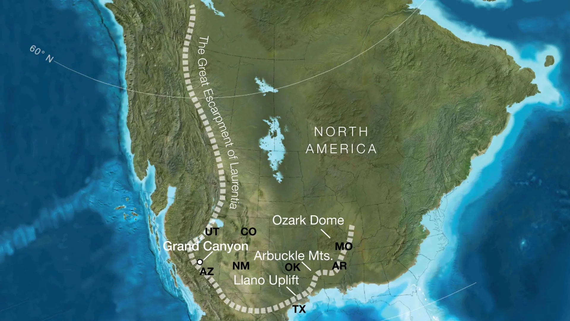
The study, led by the University of Southampton, suggests that approximately 800 million years ago, the supercontinent Rodinia began a violent, protracted breakup. As the massive landmass fractured, it gave rise to a "great escarpment"—a gargantuan cliff system that dwarfed anything found on Earth today.
These towering ramparts, estimated to have reached heights of nearly one kilometer, stretched for thousands of kilometers across what is now the North American continent. The team’s findings suggest this geological feature acted as a continental rim, crossing regions that today encompass Arizona, Utah, Idaho, Wyoming, Colorado, Texas, Oklahoma, Arkansas, Missouri, and Illinois.
"Our paper suggests the canyon’s basement rocks were progressively brought to the surface as part of an immense escarpment that developed during the breakup of an ancient supercontinent," explains Thomas Gernon, Professor of Earth Science at the University of Southampton and lead author of the study.
A Chronology of Continental Transformation
To reconstruct a landscape that vanished hundreds of millions of years ago, the international research team—comprising experts from the University of Southampton, the GFZ Helmholtz Centre for Geosciences, the University of Potsdam, and the University of Illinois Urbana-Champaign—employed a sophisticated methodology. By integrating reconstructions of plate tectonic movements with predictive models of landscape evolution, they were able to "reverse-engineer" the topography of the Neoproterozoic era.
The Rodinia Breakup (c. 800 Million Years Ago)
As Rodinia fractured, the tectonic stress created steep, mountainous ridges along the edges of Laurentia (the ancient core of North America). The study indicates that the future site of the Grand Canyon sat in a position strikingly similar to modern-day escarpments found in the Drakensberg of South Africa or the Serra do Mar in Brazil.
The Era of Massive Erosion (800 Million – 500 Million Years Ago)
Over tens of millions of years, this colossal cliff system migrated inland, driven by relentless weathering and erosion. The researchers estimate that this process was so aggressive that it stripped away between five and eight kilometers of rock in various locations. This massive denudation explains the "missing" rock record that has puzzled geologists for generations.
The Great Unconformity (The Cambrian Boundary)
By the time the Cambrian period arrived—the era defined by the rapid diversification of complex life—the landscape had been leveled, preparing the ground for the massive accumulation of sedimentary layers that eventually formed the upper strata of the Grand Canyon.
Supporting Data: Peeling Back the Layers
The hypothesis that a vast escarpment once dominated the North American interior is supported by empirical evidence that has long existed but remained poorly understood. Geologists have known for decades that five to ten kilometers of rock disappeared from the southwestern United States long before the Colorado River began its modern carving process roughly five to six million years ago.
The team’s data provides a mechanical explanation for this phenomenon. By comparing the ancient North American landscape to contemporary active margins, the researchers demonstrated that tectonic uplift associated with continental rifting creates the exact conditions—steep slopes and high elevation—necessary for high-intensity erosion.
"This long-lived tectonic landscape provides a missing piece in understanding why erosion associated with the Great Unconformity varies so dramatically across the southwestern US," says Prof. Gernon. "Our work suggests that tectonic uplift related to continental rifting and breakup created both steep slopes and high ground, providing the mountainous terrain that rivers and glaciers could readily erode."
Official Perspectives: Rethinking Earth’s History
The implications of the study extend far beyond the borders of Arizona. By reinterpreting the Grand Canyon as the byproduct of a massive, ancient escarpment, the researchers have offered a new lens through which to view the evolution of Earth’s surface.
"Today’s escarpments in Africa, Brazil, India, and Antarctica provide windows into the forces that shape continents over hundreds of millions of years," says Prof. Gernon. "By comparing the Grand Canyon’s ancient history with active landscapes like the Great Escarpment of South Africa, we are able to see North America’s most iconic geologic landmark in an entirely new light."
The research suggests that this ancient mountain rim was not just a scenic feature; it was a primary driver of continental development. It dictated the drainage patterns of early rivers, governed the deposition of sediments, and influenced the encroaching of shallow seas that would eventually host the "Cambrian Explosion."
Broader Implications for Global Geology
The findings are likely to trigger a re-evaluation of geological records across the globe. Many continental interiors contain similar "gaps" or unconformities that have been difficult to explain through localized tectonic activity alone.
By framing these features as remnants of ancient continental rifting, geologists may now have a standardized model to explain why certain regions appear "stripped" of their geological history.
Shaping the Path Forward
- Redefining Continental Records: The study suggests that "Great Unconformities" are not merely local anomalies but signatures of supercontinent cycles.
- Climate and Biodiversity: The formation of these mountainous rims likely altered global circulation patterns, potentially influencing the environmental conditions that allowed complex life to flourish during the Cambrian period.
- Future Mapping: Geologists can now use the team’s model to predict where other hidden, deep-crustal exposures might exist within ancient continental cores, potentially aiding in the identification of mineral resources or deep-earth structures.
Conclusion: The Canyon as a Mirror to the Past
The Grand Canyon is often described as a window into the past, but the new research reveals it is also a mirror of Earth’s restless, shifting tectonic nature. The realization that the canyon’s deepest layers were laid bare by a mountain range that existed half a billion years before the first dinosaur walked the Earth reminds us of the sheer scale of geological time.
As we look at the sun-drenched walls of the canyon, we are no longer just looking at the work of a river. We are seeing the scarred remains of a prehistoric mountain rim, a silent testament to the breakup of Rodinia, and the relentless, grinding power of time. The Great Unconformity, once considered a void in our knowledge, has finally begun to speak, telling a story of continental majesty that dwarfs the modern landscape and fundamentally alters our understanding of how continents are built, broken, and reborn.