
The Arctic, long viewed as the planet’s frozen sentinel, is undergoing a profound and troubling metamorphosis. For nearly fifty years, continuous satellite surveillance has chronicled a steady, inexorable retreat of the sea ice that serves as the region’s cooling mechanism. This is not merely a seasonal fluctuation; it is a fundamental shift in the geophysical character of the Arctic Ocean. As the ice becomes younger, thinner, and increasingly ephemeral, scientists warn that we are approaching a threshold that could irrevocably alter the global climate system.
The Seasonal Pulse and the Satellite Record
To understand the gravity of the current situation, one must first appreciate the Arctic’s natural rhythm. For millennia, the Arctic Ocean has functioned like a giant, pulsing lung. Throughout the long, sunless winter, ice expands, reaching its maximum extent in March. As the spring sun returns and temperatures climb, the ice pack retreats, reaching its minimum footprint in September.
This cycle, once predictable and robust, has been fundamentally disrupted. Since late 1978, when NASA’s Nimbus-7 spacecraft began the first continuous satellite monitoring of the region, the trend has been unambiguously downward. The data—now curated by institutions including NASA and the National Snow and Ice Data Center (NSIDC)—paints a picture of a shrinking cryosphere.
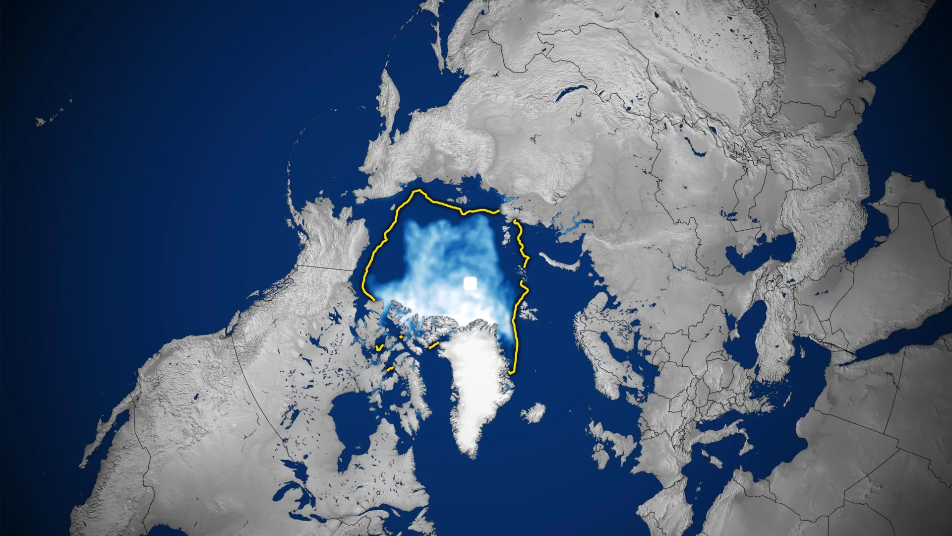
In 2026, the Arctic reached its annual minimum on September 12, covering a mere 4.6 million square kilometers (1.78 million square miles). This figure, while not the lowest in history, tied the 2008, 2010, and 2025 records, marking the 10th-lowest level since the satellite era began. More telling than any single year is the long-term trajectory: every summer from 2007 through 2026 has ranked among the 20 lowest September sea ice extents ever recorded.
A Chronology of Decline: From Resilience to Fragility
The decline of Arctic ice has not occurred at a uniform pace. The late 20th century saw the beginnings of a retreat, but the rate of loss accelerated sharply during the 2000s.
- 1978–1999: The Baseline Era. During the first two decades of satellite observation, sea ice extents were relatively stable, though the foundations of the current decline were already being laid.
- 2000–2012: The Acceleration Phase. The turn of the millennium marked a turning point. The Arctic experienced a succession of record-shattering low levels, culminating in the absolute record low in September 2012, when the ice pack retreated further than at any other point in human history.
- 2013–2026: The Stabilization Paradox. In the last decade, the rate of summer ice loss has exhibited a period of relative, albeit fragile, stability. Researchers note that this is not a sign of recovery, but rather a temporary buffering effect. Increased cloud cover over the Arctic, for instance, has acted as a shield, reflecting incoming solar radiation and curbing the intensity of summer melting. However, even with this temporary reprieve, current ice levels remain drastically lower than historical averages.
Supporting Data: The Anatomy of a Thinner Ocean
The most alarming development is not just the loss of area, but the loss of volume and age. Historically, the Arctic was dominated by "multiyear ice"—ancient, thick, and resilient ice that survived multiple summers. This ice acted as a stabilizing force for the entire region.
Satellite data now reveals that the Arctic is increasingly dominated by "first-year ice." This thin, fragile slush forms during the winter and is highly susceptible to melting as soon as the warmer months arrive. Because first-year ice lacks the thickness of its multiyear predecessor, it is easily broken up by winds and waves, accelerating the melting process in a self-reinforcing feedback loop.
This phenomenon is not limited to summer. The winter maximum—when the Arctic should be at its most robust—is also failing. In March 2026, the annual maximum statistically tied the 2025 record as the lowest winter peak in the satellite record. When the ocean fails to freeze over effectively during the winter, the starting point for the following summer’s melt is already compromised, setting the stage for even further depletion.
The Mechanics of Monitoring: Watching Through the Clouds
Monitoring the Arctic is an immense technical challenge. The region is often shrouded in persistent, thick cloud cover, which renders standard visible-light photography useless. To solve this, scientists rely on passive microwave sensors.
Microwave energy is emitted naturally by the Earth’s surface, and liquid water and frozen seawater emit these signals at distinct frequencies. Because microwaves can penetrate clouds, satellites—from the legacy Nimbus-7 and DMSP programs to the modern GCOM-W satellite operated by the Japan Aerospace Exploration Agency—can provide a continuous, high-resolution view of the ice pack regardless of weather conditions.
The maps produced by these sensors are essential, yet they contain a small caveat: the "pole hole." This is a circular region at the North Pole where, due to the orbital geometry of the satellites, no direct measurements are taken. Scientists account for this area by assuming it remains ice-covered, a standard scientific convention that allows for a comprehensive, if slightly estimated, total sea ice extent.
Official Responses and Scientific Consensus
The consensus among climate researchers is clear: while natural climate patterns—such as the Arctic Oscillation, which governs atmospheric circulation and wind patterns—do influence ice levels from year to year, they are insufficient to explain the persistent, long-term decline.
NASA researchers and scientists at the NSIDC emphasize that while natural variability plays a role in the short-term stabilization of ice levels, it is being overwhelmed by the broader trend of rising global temperatures. The "noise" of natural climate fluctuations is increasingly being drowned out by the "signal" of human-induced climate change.
"The Arctic is not just losing ice; it is losing its ability to regulate its own temperature," says one lead climate researcher. The official stance of these agencies remains one of urgent observation, urging that the current data serves as an early warning system for the entire planet.
Implications: A Future Without Ice?
The implications of an ice-free Arctic are staggering. We are currently witnessing a transition that has not occurred for millennia. Scientists project that the Arctic Ocean could become essentially free of sea ice during the summer at least once before the middle of the 21st century.
An ice-free Arctic would represent a fundamental change in the Earth’s albedo, or reflectivity. Currently, the bright white ice reflects the majority of the sun’s energy back into space. As this is replaced by dark, open ocean, the region will absorb significantly more heat, creating a "positive feedback loop" that accelerates global warming.
Furthermore, the loss of Arctic ice threatens the delicate ecosystems that depend on the platform for hunting and breeding, from microscopic algae to the iconic polar bear. Beyond the environmental toll, the opening of the Arctic poses geopolitical and economic questions, as new shipping routes and resource extraction opportunities emerge in a region that was once inaccessible.
As we look toward the future, the satellite data serves as a stark reminder of the planet’s fragility. The "frozen North" is no longer the static, unchanging region of the past. It is a dynamic, rapidly evolving landscape, and the observations captured by satellites over the last 48 years are not just data points—they are the blueprints of a changing world. The question remains: can the global community adapt to a world where the Arctic, once a permanent feature of the map, becomes a seasonal memory?