
Introduction: A Vanishing Oasis
When astronaut John Glenn orbited the Earth in 1962, he peered down at the American Southwest and noted a striking, verdant ribbon of green slicing through the arid, sun-scorched landscape of the Chihuahuan Desert. This oasis, located northwest of El Paso, Texas, was not a natural fluke; it was a testament to human ingenuity. By constructing a series of dams and reservoirs along the Rio Grande, settlers had transformed a harsh, scrub-brush environment into a thriving agricultural hub.
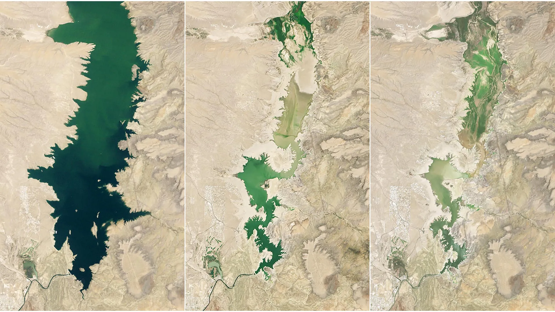
Today, that same landscape tells a story of profound environmental fragility. The "green valley" Glenn once admired is currently facing its most severe test in over half a century. As extreme heat and unprecedented drought conditions converge, the lifeblood of the region—the Rio Grande—is struggling to sustain the crops that define the area, including alfalfa, cotton, onions, pecans, and the iconic Hatch green chile. As of the summer of 2026, the reservoir that once acted as the region’s primary insurance policy against aridity, Elephant Butte, has dwindled to a skeletal 1.4 percent of its total capacity.
The Chronology of a Crisis: A Basin in Retreat
The current crisis in the Rio Grande basin is the result of a compounding series of meteorological failures. While the region is accustomed to the cyclic nature of Western drought, the events of the mid-2020s have pushed the system into uncharted territory.
The 2026 Snowmelt Anomaly
The downward spiral accelerated in early 2026. The Rio Grande relies heavily on the "water tower" of the southern Rocky Mountains, where winter snowpack serves as a natural reservoir, releasing water gradually throughout the spring and summer. However, the 2026 season witnessed the earliest snowmelt on record. Instead of a slow, sustained runoff, the water arrived too early and too fast, leaving the basin thirsty and dry as temperatures spiked in late spring and early summer.
A Historical Comparison of Elephant Butte
The descent of Elephant Butte Reservoir serves as a grim barometer for the health of the basin:
- The Golden Years (1985–2000): During the latter decades of the 20th century, water levels remained consistently high, providing a sense of stability for farmers and municipal planners alike.
- The 2013 Warning: A severe drought previously tested the limits of the reservoir, driving it down to 2.9 percent of its capacity by July 8, 2013. At the time, many viewed it as a "once-in-a-generation" event.
- The 2026 Collapse: The current situation has eclipsed the 2013 crisis. Captured in satellite imagery on July 27, 2026, the reservoir bottomed out at a staggering 1.4 percent of its capacity. Where once deep blue water facilitated recreation and irrigation, there is now only exposed silt, cracked mud, and long-submerged debris.
Supporting Data: The Science of Scarcity
The decline of Elephant Butte is not merely a matter of evaporation; it is a symptom of a broader hydrological imbalance. The interplay between groundwater and surface water has become increasingly volatile. As surface water becomes scarce, local agricultural districts and municipalities are forced to lean more heavily on groundwater pumping, a practice that, in some areas, can further deplete the base flow of the river itself.
The sediment levels within the reservoir have become so pronounced that they have begun to bury boat ramps and infrastructure at Elephant Butte Lake State Park. This is not just a logistical inconvenience for recreational users; it is a physical manifestation of a watershed that is effectively "silting up" and losing its ability to store meaningful volumes of water even when rains do occur.
Official Responses and Adaptive Management
State and local officials are currently in a state of high-alert resource management. In late July 2026, the Elephant Butte Irrigation District (EBID) took the difficult step of ending agricultural water releases. While this decision effectively curtailed the irrigation season for many farmers, it was a necessary sacrifice to prevent the reservoir from reaching a state of total depletion.
Government agencies are now navigating a complex legal and environmental landscape. The Rio Grande Compact, which governs the division of water between Colorado, New Mexico, and Texas, is under unprecedented pressure. As water supplies shrink, the tension between these stakeholders grows. Managing these limited supplies requires a near-constant recalibration of how water is stored, allocated, and shared, with officials often forced to choose between the immediate economic survival of agricultural communities and the long-term sustainability of the river’s ecosystem.
Implications: The Future of the Valley
The implications of this drying trend extend far beyond the farm gate. The Rio Grande Valley supports a vast network of communities that are entirely dependent on this surface-water-groundwater nexus.
- Economic Impact: The agricultural industry in the valley is a multi-million dollar economic engine. The loss of reliable irrigation threatens the viability of crops that are sensitive to timing, such as the Hatch green chile, which requires precise watering schedules to achieve its signature flavor profile.
- Municipal Security: As the river level drops, the quality of water can degrade, and the cost of treatment can rise. Cities that rely on the Rio Grande for drinking water are beginning to face the reality of restricted usage and the need for expensive infrastructure upgrades to access deeper, less reliable aquifers.
- Ecological Collapse: The Rio Grande is not just a resource; it is a living ecosystem. Shrinking flows destroy riparian habitats, threaten endangered fish species, and lead to the loss of biodiversity that has existed in the valley for millennia.
NASA’s Role: High-Tech Eyes in the Sky
As the situation on the ground grows more dire, the scientific community is turning to space-based assets to find solutions. NASA’s Western Water Action Office (WWAO) has become an essential partner in helping water managers make sense of a chaotic hydrological environment.
Satellite-Driven Modeling
One of the most promising initiatives involves a model that integrates satellite measurements of soil moisture and evapotranspiration. By combining these data points, researchers can create a "near-real-time" view of water availability. This system supplements the traditional allocation methods used by the Elephant Butte Irrigation District, providing a more granular understanding of how much water is actually available in the soil versus how much is being lost to the atmosphere.
Monitoring Groundwater and Flow
Another critical project utilizes a multi-layered data approach. By combining satellite measurements of water surface heights with drone-based reconnaissance and ground-level sensors, researchers are mapping the influence of groundwater pumping on the river’s flow. This data is vital for water rights adjudication. It allows officials to see, with scientific precision, where pumping is negatively impacting the river, providing the evidence needed to create more equitable and sustainable water-usage policies.
Federal Collaboration
Beyond individual projects, NASA scientists are deeply involved in a comprehensive federal study focused on the Upper Rio Grande. This initiative is designed to be a long-term roadmap. Its goals are three-fold:
- Need Assessment: Quantifying exactly how much water the region requires to sustain its current population and economy.
- Availability Forecasting: Using predictive models to estimate water availability under various climate scenarios, from moderate drought to extreme, multi-year dry spells.
- Tool Development: Creating accessible, data-driven software tools that local managers can use to make rapid, informed decisions during extreme events.
Conclusion: A New Era of Water Stewardship
The view of the Rio Grande from space today is vastly different from the one John Glenn saw in 1962. The vibrant green that once stood out against the desert floor is increasingly punctuated by shades of brown and gray. Yet, this is not necessarily a story of total failure. It is, instead, a story of an essential transition.
The era of assuming that the Rio Grande would provide a predictable, bottomless supply of water is over. In its place is a new era of "data-driven stewardship." By leveraging the insights provided by NASA and prioritizing sustainable management over historical water rights, the communities of the Rio Grande basin are attempting to navigate a warming future. Whether the valley can maintain its status as a green oasis in the desert will depend on the ability of humans to adapt to the new realities of a drier, more volatile world. The technology exists to track the decline, but the future of the Rio Grande will be decided by the choices made on the ground, in the boardrooms of irrigation districts, and in the halls of government.